IMAGES TAKEN NEAR TO
Appledore Gardens, HAYWARDS HEATH, RH16 2ES
Introduction
This page details the photographs taken nearby to Appledore Gardens, RH16 2ES by members of the Geograph project.
The Geograph project started in 2005 with the aim of publishing, organising and preserving representative images for every square kilometre of Great Britain, Ireland and the Isle of Man.

There are currently over 7.5m images from over14,400 individuals and you can help contribute to the project by visiting https://www.geograph.org.uk
Image Map
Images are licensed for reuse under creativecommons.org/licenses/by-sa/2.0
Notes
- Clicking on the map will re-center to the selected point.
- The higher the marker number, the further away the image location is from the centre of the postcode.
Image Listing (36 Images Found)
Images are licensed for reuse under creativecommons.org/licenses/by-sa/2.0
Image
Details
Distance
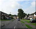
1
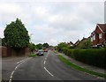
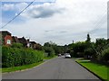
Appledore Gardens, Lindfield
Viewed from the point where the road turns north becoming Backwoods Lane. This section was developed in the late 1950s on a former field called Backworth according to Lindfield's 1845 tithe map.
Image: © Simon Carey
Taken: 15 Aug 2015
0.02 miles
2
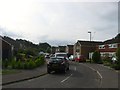
Pelham Road, Lindfield
A residential road that runs in a crescent off Appledore Gardens that was developed in the late 1950s.
Image: © Simon Carey
Taken: 15 Aug 2015
0.05 miles
3
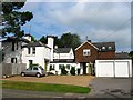
Backwoods, Backwoods Lane, Lindfield
A former farmhouse that now lies buried beneath residential Lindfield. Originally known as Backwood Farm it was the only building between the common and Scrase Stream until the 1940s when its former access road, Backwoods Lane, began to be developed.
Image: © Simon Carey
Taken: 15 Aug 2015
0.08 miles
4
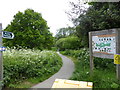
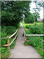
Public footpath going south through Scrace Valley Nature Reserve
Image: © Shazz
Taken: 20 May 2016
0.09 miles
5
Footpath to Lindfield
Linking Hanbury Lane, Haywards Heath to Backwoods Lane in Lindfield. Here the footpath crosses Scrase Stream in the Scrase Valley Nature Reserve.
Image: © Simon Carey
Taken: 30 Aug 2007
0.10 miles
6
Beckworth Lane, Lindfield
A residential road that heads west off Image that was built in the late 1940s. Viewed from the junction with Image
Image: © Simon Carey
Taken: 6 Sep 2015
0.11 miles
7
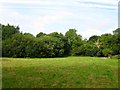
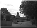
Pick Gate
The name of the meadow according to Lindfield's 1845 tithe map that is now part of Scrase Valley Nature Reserve, a 15 acre site of wetland and woodland which provides a small green barrier between Lindfield and Haywards Heath.
Image: © Simon Carey
Taken: 15 Aug 2015
0.12 miles
8
Beckworth Close, Lindfield
A private cul de sac off Image that was developed in the late 1940s.
Image: © Simon Carey
Taken: 6 Sep 2015
0.13 miles
9
Blackthorns Close, Lindfield
Small cul de sac off Image which also provides access to Image and Blackthorns Primary Academy. These four bungalows are located on a private drive to the south of the close and were built in the 1980s.
Image: © Simon Carey
Taken: 6 Sep 2015
0.14 miles
10
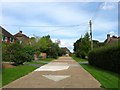
Appledore Gardens, Lindfield
A residential road that runs from West Common to Backwoods Lane that was developed in stages; the eastern part was built in the late 1950s whilst the western end in view was not completed until the mid 1960s.
Image: © Simon Carey
Taken: 15 Aug 2015
0.14 miles