IMAGES TAKEN NEAR TO
Appledore Court, West Common, HAYWARDS HEATH, RH16 2BG
Introduction
This page details the photographs taken nearby to Appledore Court, West Common, RH16 2BG by members of the Geograph project.
The Geograph project started in 2005 with the aim of publishing, organising and preserving representative images for every square kilometre of Great Britain, Ireland and the Isle of Man.

There are currently over 7.5m images from over14,400 individuals and you can help contribute to the project by visiting https://www.geograph.org.uk
Image Map
Images are licensed for reuse under creativecommons.org/licenses/by-sa/2.0
Notes
- Clicking on the map will re-center to the selected point.
- The higher the marker number, the further away the image location is from the centre of the postcode.
Image Listing (44 Images Found)
Images are licensed for reuse under creativecommons.org/licenses/by-sa/2.0
Image
Details
Distance
5
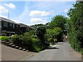
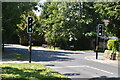
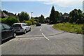
Denman's Lane, Lindfield
The western end of the lane that once opened out onto West Common but now ends at the junction with Hickman's Lane. This end of the road wasn't developed until after the Second World War.
Image: © Simon Carey
Taken: 18 Jul 2015
0.06 miles
6
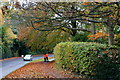
Men at Work, Lindfield, Sussex
After a heavy leaf-fall, council workers are busy clearing the wet leaves from the footpath on the outskirts of Lindfield.
Image: © Peter Trimming
Taken: 4 Nov 2011
0.07 miles
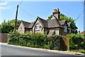
8
Oakfield Close, Lindfield
Small cul de sac off Hickman's Lane that was built in the late 1950s or early 1960s.
Image: © Simon Carey
Taken: 18 Jul 2015
0.07 miles
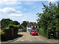
10
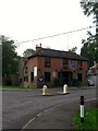
The Witch Inn, Sunte Avenue, Lindfield
Opened in 1845 at an old crossroads called Pickesgreen Cross on what was then open fields. Originally called the Bricklayers Arms it acquired its current name after the First World War. For a number of years from the mid 1980s up until around 2007 it was owned by former Derby County, Brighton & Hove Albion and Republic of Ireland international footballer Gerry Ryan.
Image: © Simon Carey
Taken: 15 Aug 2015
0.10 miles