IMAGES TAKEN NEAR TO
Copyhold Lane, HAYWARDS HEATH, RH16 1XT
Introduction
This page details the photographs taken nearby to Copyhold Lane, RH16 1XT by members of the Geograph project.
The Geograph project started in 2005 with the aim of publishing, organising and preserving representative images for every square kilometre of Great Britain, Ireland and the Isle of Man.

There are currently over 7.5m images from over14,400 individuals and you can help contribute to the project by visiting https://www.geograph.org.uk
Image Map
Images are licensed for reuse under creativecommons.org/licenses/by-sa/2.0
Notes
- Clicking on the map will re-center to the selected point.
- The higher the marker number, the further away the image location is from the centre of the postcode.
Image Listing (147 Images Found)
Images are licensed for reuse under creativecommons.org/licenses/by-sa/2.0
Image
Details
Distance
1

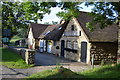
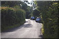
Brighton Cottages, Copyhold Lane
Built in the first decade of the 20th century and containing three cottages which belong like its neighbour to the east, Image, to the Borde Hill Estate.
Image: © Simon Carey
Taken: 18 Jul 2015
0.01 miles
3
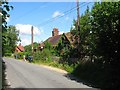
Neville Cottages, Copyhold Lane
A terrace of four cottages located to the east of Image which is just visible to the left. Not marked on the 1910 OS map but do appear on the 1938 edition.
Image: © Simon Carey
Taken: 18 Jul 2015
0.03 miles
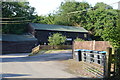
5

The Old Sawmill, Copyhold Lane
The sawmill first appeared between the wars and was closed down a few years ago and now converted into small business units.
Image: © Simon Carey
Taken: 17 Feb 2015
0.03 miles
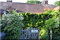
6
Honeywood Field
The name of the field according to Ardingly's 1840 tithe map that is located to the south of Copyhold Lane. See Image for the Cuckfield part of the field.
Image: © Simon Carey
Taken: 18 Jul 2015
0.04 miles
7
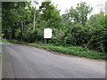
The Old Sawmills
A small industrial site
Image: © Dave Spicer
Taken: 30 Aug 2009
0.06 miles
9

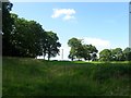
Tarnes Field
The name of the field according to Cuckfield's 1843 tithe map that is bounded by Copyhold lane to the north, Borde Hill lane to the west and Image to the south.
Image: © Simon Carey
Taken: 17 Feb 2015
0.06 miles