IMAGES TAKEN NEAR TO
Borde Hill Lane, HAYWARDS HEATH, RH16 1XR
Introduction
This page details the photographs taken nearby to Borde Hill Lane, RH16 1XR by members of the Geograph project.
The Geograph project started in 2005 with the aim of publishing, organising and preserving representative images for every square kilometre of Great Britain, Ireland and the Isle of Man.

There are currently over 7.5m images from over14,400 individuals and you can help contribute to the project by visiting https://www.geograph.org.uk
Image Map
Images are licensed for reuse under creativecommons.org/licenses/by-sa/2.0
Notes
- Clicking on the map will re-center to the selected point.
- The higher the marker number, the further away the image location is from the centre of the postcode.
Image Listing (166 Images Found)
Images are licensed for reuse under creativecommons.org/licenses/by-sa/2.0
Image
Details
Distance
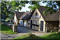
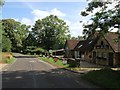
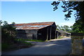
1
Farm buildings on Bordehill Lane
See http://www.geograph.org.uk/photo/4576864 for a view the other way.
Image: © Shazz
Taken: 12 Oct 2016
0.01 miles
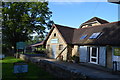
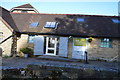
3
Naldred Farm Offices, Borde Hill Lane
Naldred Farm's original outbuildings were located between the farmhouse and the road on the western side. These were then moved to this location early in the 20th century utilising local sandstone in their construction. A few barns to the rear are still used by the Borde Hill Estate for agricultural purposes but the rest of the complex is now used for business units containing the sales office of an electronics firm; a holistic health clinic; and a place to buy or hire marquee tents.
Image: © Simon Carey
Taken: 18 Jul 2015
0.01 miles
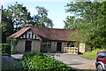
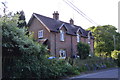
6
Mill House, Borde Hill Lane
Originally built as part of the complex of farm buildings belonging to Naldred Farm which included Image located immediately to the north. Now home to a firm of business consultants the mill part of the name most likely derives from the former nearby sawmill.
Image: © Simon Carey
Taken: 18 Jul 2015
0.02 miles
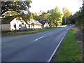
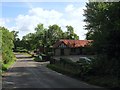
8
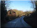
60-61, Borde Hill Lane
The numbering refers to the estate number of the cottages which are part of the Borde Hill Estate. The cottages date from the 19th century whilst beyond just visible on the right are the buildings of Naldred Farm which now seem to be part of a small business park also belonging to Borde Hill. Between the junction with Copyhold Lane and Upper Ryelands Bridge the lane serves as a parish boundary with all buildings on the western side belonging to Cuckfield and all those on the eastern side part of Ardingly.
Image: © Simon Carey
Taken: 17 Feb 2015
0.03 miles