IMAGES TAKEN NEAR TO
Old Wickham Lane, HAYWARDS HEATH, RH16 1UP
Introduction
This page details the photographs taken nearby to Old Wickham Lane, RH16 1UP by members of the Geograph project.
The Geograph project started in 2005 with the aim of publishing, organising and preserving representative images for every square kilometre of Great Britain, Ireland and the Isle of Man.

There are currently over 7.5m images from over14,400 individuals and you can help contribute to the project by visiting https://www.geograph.org.uk
Image Map
Images are licensed for reuse under creativecommons.org/licenses/by-sa/2.0
Notes
- Clicking on the map will re-center to the selected point.
- The higher the marker number, the further away the image location is from the centre of the postcode.
Image Listing (40 Images Found)
Images are licensed for reuse under creativecommons.org/licenses/by-sa/2.0
Image
Details
Distance
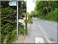
1
Looking into Old Wickham Lane
This is a public footpath.
Another view of the junction with Balcombe Road is at http://www.geograph.org.uk/photo/2507507.
Image: © Shazz
Taken: 20 May 2016
0.04 miles
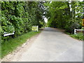
2
Old Wickham Lane junction with Balcombe Road
Image: © Dave Spicer
Taken: 10 Jul 2011
0.06 miles
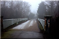
4
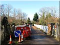
Bridge, Old Wickham Lane
Not built at the time of the railway but added as an access route to Image in the last quarter of the 19th century.
Image: © Simon Carey
Taken: 17 Feb 2015
0.07 miles
5
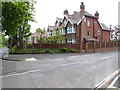
House on junction of Barnmead and Balcombe Road
Image: © Shazz
Taken: 20 May 2016
0.07 miles
6
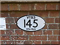
Engineers Line Reference, Old Wickham Lane
This oval shaped sign is an ELR (Engineers Line Reference). A sign similar to this will appear on every rail bridge in the UK where a Network Rail track crosses. 145 is the bridge number for this line, VTB3 is the line ID (Victoria To Brighton 3), and the distance from the start point (probably London Victoria station) is given in miles and chains. A chain is 22 yards, 1/80 of a mile. It might seem an odd unit to use, but it was the prevailing convention when most of Britain's railways were built and it makes more sense to stick with it rather than convert the entire measurement infrastructure to metric. This website tells you more about ELRs http://deaves47.zxq.net/ELRs/ELR0.htm
Image: © Danny P Robinson
Taken: 27 Jan 2013
0.07 miles
7
Old Wickham Lane crossing the main line from London to Brighton
Image: © Dave Spicer
Taken: 10 Jul 2011
0.07 miles
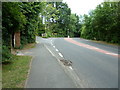
8
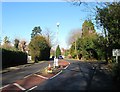
Balcombe Road, Haywards Heath
A busy C road that links haywards heath to Balcombe and predates the town for many centuries it formed part of the parish boundary between Cuckfield and Lindfield. Some police tape around the lamp post suggests a motoring accident has occurred here recently whilst on the right is the entrance to Old Wickham Lane.
Image: © Simon Carey
Taken: 17 Feb 2015
0.07 miles
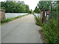
9
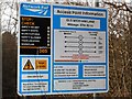
Rail Access Point Information, Old Wickham Lane
This access point is where Old Wickham Lane crosses the London to Brighton mainline.
Image: © Danny P Robinson
Taken: 27 Jan 2013
0.08 miles