IMAGES TAKEN NEAR TO
Burrell Road, HAYWARDS HEATH, RH16 1TL
Introduction
This page details the photographs taken nearby to Burrell Road, RH16 1TL by members of the Geograph project.
The Geograph project started in 2005 with the aim of publishing, organising and preserving representative images for every square kilometre of Great Britain, Ireland and the Isle of Man.

There are currently over 7.5m images from over14,400 individuals and you can help contribute to the project by visiting https://www.geograph.org.uk
Image Map
Images are licensed for reuse under creativecommons.org/licenses/by-sa/2.0
Notes
- Clicking on the map will re-center to the selected point.
- The higher the marker number, the further away the image location is from the centre of the postcode.
Image Listing (104 Images Found)
Images are licensed for reuse under creativecommons.org/licenses/by-sa/2.0
Image
Details
Distance
1
Flowserve, Burrell Road, Haywards Heath
A multinational manufacturer of valves and pumps. Burrell Road industrial estate was created in the 1960s when one of its businesses included the Norris Brothers, responsible for designing and making Donald Campbell's Bluebird K7 which would crash on Coniston Water in an attempt to break the land speed record.
Image: © Simon Carey
Taken: 17 Feb 2015
0.02 miles
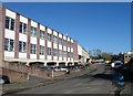
2

Mencap, Burrell Road, Haywards Heath
The charity's offices are part of a former factory which has been subdivided into smaller units on Burrell Industrial Estate. The block in the distance is Image
Image: © Simon Carey
Taken: 12 Apr 2015
0.04 miles
3
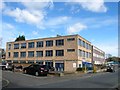
Norris House, Burrell Road, Haywards Heath
Named after Norris Brothers whose Burgess Hill engineering firm moved here in the early 1960s and are chiefly remembered for designing Donald Campbell's Bluebird jet cars and boats. The engineering firm has long gone and the building is now used as offices.
Image: © Simon Carey
Taken: 30 Mar 2015
0.06 miles
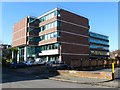
4
Nuffield Hospital, Burrell Road, Haywards Heath
The light industrial estate on Burrell Road was opened in the mid 1960s on a former field called Long Mead, according to Cuckfield's 1843 tithe map. Originally a warehouse the site later became a pharmaceutical works which was eventually replaced by the current private hospital opened in 1993.
Image: © Simon Carey
Taken: 17 Feb 2015
0.07 miles
5
Euronics Optimum, Burrell Road, Haywards Heath
A kitchen appliance retailer on the Burrell Industrial Estate that lies opposite the private Nuffield Hospital. Beyond is the embankment containing the London-Brighton railway.
Image: © Simon Carey
Taken: 12 Apr 2015
0.07 miles
6
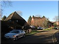
Harlands Farmhouse, Bridgers Mill, Haywards Heath
Dating from the late 16th century and now buried within a residential estate built upon the fields it once farmed. The building on the left is Harlands Barn and dates from the 16th century but has now been converted to residential use.
Image: © Simon Carey
Taken: 17 Feb 2015
0.08 miles
7
Chester House, Harlands Road, Haywards Heath
Built in the 1960s and located on the corner of Burrell Road and Harlands Road.
Image: © Simon Carey
Taken: 17 Feb 2015
0.08 miles
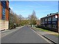
8
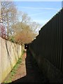
Bridleway, Haywards Heath
This section links Turners Mill Road and Burrell Road. The bridleway is the remnant of a former medieval highway that linked Cuckfield to Lindfield. It left Cuckfield via Hatchgate Lane through Blunts Wood a section that also still survives. Once it reaches Haywards Heath it follows Blunts Wood Road to the junction with Penland Road where it originally crossed the grounds of what is now Haywards Heath College that was originally Harlands Secondary School. This was removed in the 1960s along with another section that has been built over by Turners Mill Road before rejoining this surviving section which originally led to a junction with the road to Mill Green which was also rerouted in the early 1840s when the railway was built. The route to Lindfield follows the course of College Road and Gander Hill where it led out onto Lindfield's West Common then continued on the eastern as Denmans Lane to the High Street. The route was still in existence in 1638 as it is marked on an estate map and called The Whappell Way, whapple being another term for a route used by horses. However, by the 1813 OS map the track ended at Harlands Farm which still lies beyond the fence to the left though is now part of a cul de sac called Bridgers Mill. Beyond the fence to the right is the private Nuffield Hospital.
Image: © Simon Carey
Taken: 12 Apr 2015
0.08 miles
9
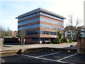
Burns House, Harlands Road, Haywards Heath
The office block was constructed in the 1980s. This is the rear view from Burrell Road.
Image: © Simon Carey
Taken: 12 Apr 2015
0.09 miles
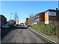
10
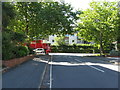
Burrell Road meets Harlands Road
Burrell Road is mainly industrial and business units.
Image: © Dave Spicer
Taken: 7 Sep 2012
0.10 miles