IMAGES TAKEN NEAR TO
Portsmouth Lane, HAYWARDS HEATH, RH16 1RU
Introduction
This page details the photographs taken nearby to Portsmouth Lane, RH16 1RU by members of the Geograph project.
The Geograph project started in 2005 with the aim of publishing, organising and preserving representative images for every square kilometre of Great Britain, Ireland and the Isle of Man.

There are currently over 7.5m images from over14,400 individuals and you can help contribute to the project by visiting https://www.geograph.org.uk
Image Map
Images are licensed for reuse under creativecommons.org/licenses/by-sa/2.0
Notes
- Clicking on the map will re-center to the selected point.
- The higher the marker number, the further away the image location is from the centre of the postcode.
Image Listing (23 Images Found)
Images are licensed for reuse under creativecommons.org/licenses/by-sa/2.0
Image
Details
Distance
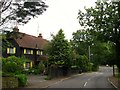
1
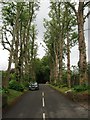
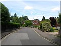
Birchen Lane, Haywards Heath
Private road off Portsmouth Lane that was originally the eastern access drive to Sunte House that was laid out towards the end of the 19th century to replace an older route a little to the south. Developed as a residential road from the 1950s and is private from the junction with Gatesmead.
Image: © Simon Carey
Taken: 15 Aug 2015
0.05 miles
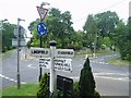
2
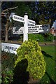
Old Direction Sign - Signpost by Portsmouth Lane/Sunte Avenue, Lindfield Parish
Black iron cap finial - 4 arms; East Sussex wood by the UC road, in parish of Lindfield (Mid Sussex District), Portsmouth Lane and Sunte Avenue Junction, with Gander Hill and Summerhill Lane, on verge at crossroads.
Surveyed
Milestone Society National ID: SX_TQ3325.
Image: © Milestone Society
Taken: Unknown
0.06 miles
3
Smallsgreen Cross, Lindfield
The old name of the crossroads where the Haywards Heath to Ardingly road once crossed the old Lindifeld to Cuckfield road. The former represented by Summerhill lane to the south and Portsmouth Lane to the north still carries out the same function and also provides the boundary between Haywards Heath and Lindfield. The latter road has long since disappeared though the current section survives as residential roads; Sunte Avenue to the east and Gander Hill to the west. Beyond the railway the former highway has been reduced to a bridleway where it hasn't been swallowed up by development.
Image: © Simon Carey
Taken: 18 Jul 2015
0.06 miles
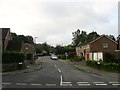
5
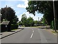
Cross Roads at Sunte Avenue
A busy mini roundabout
Image: © Nigel Freeman
Taken: 2 Jul 2005
0.08 miles
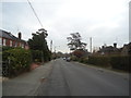
7
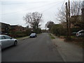
17-19, Portsmouth Lane, Haywards Heath
Built in 1922 with number 19 named Cottage Pie. On the Haywards Heath side of the lane, those dwellings on the eastern side are in Lindfield. The lane drops down to Image
Image: © Simon Carey
Taken: 15 Aug 2015
0.10 miles
8
Portsmouth Bridge, Lindfield
Carrying Portsmouth lane over an unnamed tributary of Scrase Stream. The lane currently marks the parish boundary between Lindfield and Haywards Heath which then follows the stream westwards. The latter expanded into the former's territory during the 1930s.
Image: © Simon Carey
Taken: 15 Aug 2015
0.12 miles
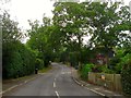
9
Gander Green, Haywards Heath
A cul de sac off Gander Hill that was built in the late 1950s along the alignment of the former drive to Sunte House.
Image: © Simon Carey
Taken: 18 Jul 2015
0.13 miles
10
Field Way, Lindfield
A small residential estate heading south of By Sunte built in the late 1960s on the site of a former field called The Ten Acres according to Lindfield's 1845 tithe map.
Image: © Simon Carey
Taken: 15 Aug 2015
0.15 miles