IMAGES TAKEN NEAR TO
Summerhill Close, HAYWARDS HEATH, RH16 1QY
Introduction
This page details the photographs taken nearby to Summerhill Close, RH16 1QY by members of the Geograph project.
The Geograph project started in 2005 with the aim of publishing, organising and preserving representative images for every square kilometre of Great Britain, Ireland and the Isle of Man.

There are currently over 7.5m images from over14,400 individuals and you can help contribute to the project by visiting https://www.geograph.org.uk
Image Map
Images are licensed for reuse under creativecommons.org/licenses/by-sa/2.0
Notes
- Clicking on the map will re-center to the selected point.
- The higher the marker number, the further away the image location is from the centre of the postcode.
Image Listing (29 Images Found)
Images are licensed for reuse under creativecommons.org/licenses/by-sa/2.0
Image
Details
Distance
1
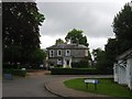
Summerhill Close, Haywards Heath
A private cul de sac off Gander Hill built between the wars.
Image: © Simon Carey
Taken: 18 Jul 2015
0.06 miles
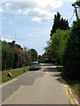
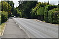
2
Gander Hill, Haywards Heath
The point where College Road becomes Gander Hill. The road was once part of the old medieval Cuckfield to Lindfield highway that skirted the northern end of the old Haywards Heath common. It left Broad Street, Cuckfield at Hatchgate Lane and followed the route of the bridleway through Paige's Wood then part of Blunt's Wood Crescent and Blunt's Wood Road. Part of the section which crossed the current grounds of Haywards Heath College was removed as public access in the 1950s with a bridleway reappearing heading east from Turners Mill Road between a housing estate and a business park before rejoining Balcombe Road prior to it crossing under the railway. Here the route becomes a highway again along College road then Gander Hill up to Smallsgreen Cross where it would have once crossed Lindfield's West Common and entered that town via Denman's Lane or Hickman's Lane. Much of Gander Hill was developed between the wars.
Image: © Simon Carey
Taken: 18 Jul 2015
0.07 miles
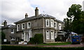
3
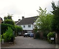
The Well House, Summerhill Lane, Lindfield
A Victorian villa on Summerhill Lane located to the south of Image On the eastern side of the lane and thus in Lindfield, those on the west are in Haywards Heath. The highway was originally known as Scrase Bridge Lane and runs north to Ardingly.
Image: © Simon Carey
Taken: 15 Aug 2015
0.09 miles
4
Summerhill court school
My prep school has a new name now but it looked just the same as it did 50 yrs ago.
Image: © Andrew Darge
Taken: 24 Sep 2006
0.10 miles
5
Tavistock and Summerhill Preparatory School, Lindfield
Originally a Victorian house called Summer Hill that was acquired in 1939 by the owners of Belvedere School located in Bolnore Road Haywards Heath that had been founded in 1888. In 1973 it merged with Tavistock Hall, then based in Heathfield East Sussex, but originally founded in the Devon town. Both were originally boys preparatory boarding schools but became co-educational in the early 1980s. The school governors voted for closure in 2011 due to dwindling numbers, however, the parents mobilised to save it and succeeded after which interest and numbers have grown again.
The white building to the right is the former lodge whilst the road to the south of the school is small residential estate built on former grounds.
Image: © Simon Carey
Taken: 15 Aug 2015
0.11 miles
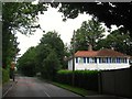
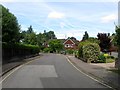
6
Dunkeld, West Common, Lindfield
Viewed from the rear access on Summerhill Lane. The house fronts onto the B2028 and was built in the 1970s.
Image: © Simon Carey
Taken: 15 Aug 2015
0.15 miles
7
Gander Green, Haywards Heath
A cul de sac off Gander Hill that was built in the late 1950s along the alignment of the former drive to Sunte House.
Image: © Simon Carey
Taken: 18 Jul 2015
0.15 miles
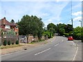
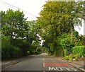
8
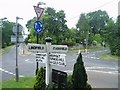
Cross Roads at Sunte Avenue
A busy mini roundabout
Image: © Nigel Freeman
Taken: 2 Jul 2005
0.16 miles
10
West Common, Lindfield
The B2028 heads south towards the junction with Summerhill Lane and Image beyond which is Haywards Heath. The road name is the sole reminder of the former common it once crossed, bounded by Summerhill Lane to the west, Hickmans Lane to the east and Sunte Avenue to the north. Marked on a 1813 OS map it had been enclosed by the time of Lindfield's 1845 tithe map. Ribbon development along the road was largely carried out between the wars.
Image: © Simon Carey
Taken: 15 Aug 2015
0.17 miles