IMAGES TAKEN NEAR TO
Ridge Green, REDHILL, RH1 5RN
Introduction
This page details the photographs taken nearby to Ridge Green, RH1 5RN by members of the Geograph project.
The Geograph project started in 2005 with the aim of publishing, organising and preserving representative images for every square kilometre of Great Britain, Ireland and the Isle of Man.

There are currently over 7.5m images from over14,400 individuals and you can help contribute to the project by visiting https://www.geograph.org.uk
Image Map
Images are licensed for reuse under creativecommons.org/licenses/by-sa/2.0
Notes
- Clicking on the map will re-center to the selected point.
- The higher the marker number, the further away the image location is from the centre of the postcode.
Image Listing (40 Images Found)
Images are licensed for reuse under creativecommons.org/licenses/by-sa/2.0
Image
Details
Distance
4
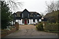
Avenue House
One of a number of large late Victorian houses built in The Avenue following the opening of Nutfield Station in 1884.
Image: © Ian Capper
Taken: 6 Mar 2010
0.09 miles
5
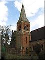
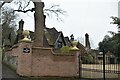
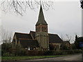
Tower, Christ Church, South Nutfield, Surrey
The church is sited on the South side of King's Cross Lane opposite the junction with The Avenue. The church was designed by Edward I'Anson and built in 1888 in an Early English style and comprises a nave of five bays, chancel, an organ chamber on the south side, a tower sited at the junction of the nave and chancel on the north side and adjacent to that and parallel with the chancel, a choir vestry, (added in 1909, also by I'Anson), and a north west porch. Extensions on the south side were added in 2001 and 2005 and the spire was re-shingled in 2006.
http://cc-nutfield.org.uk/main_home.html
Image: © Richard Rogerson
Taken: 3 Apr 2010
0.10 miles
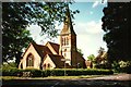
7
Christ Church, South Nutfield
Built in 1888 to a design of Edward I'Anson.
Image: © Ian Capper
Taken: 6 Mar 2010
0.10 miles
9
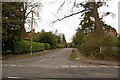
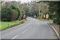
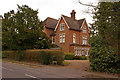
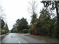
The Avenue
A road running from Kings Cross Lane (in the foreground in this photo) towards Nutfield Station. Although there has been some more modern infilling, most houses were built in the late 1900s, following the opening of Nutfield station in 1884. Two of the larger houses can be seen in this photo: Netherleigh on the left (see Image) and Avenue House on the right (see Image).
Image: © Ian Capper
Taken: 6 Mar 2010
0.10 miles
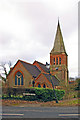
10
Christ Church, South Nutfield, Surrey
The church is sited on the South side of King's Cross Lane opposite the junction with The Avenue. The church was designed by Edward I'Anson and built in 1888 in an Early English style and comprises a nave of five bays, chancel, an organ chamber on the south side, a tower sited at the junction of the nave and chancel on the north side and adjacent to that and parallel with the chancel, a choir vestry, (added in 1909, also by I'Anson), and a north west porch. Extensions on the south side were added in 2001 and 2005 and the spire was re-shingled in 2006.
Image: © Richard Rogerson
Taken: 11 Jan 2012
0.10 miles