IMAGES TAKEN NEAR TO
St. Georges Road, REDHILL, RH1 5RD
Introduction
This page details the photographs taken nearby to St. Georges Road, RH1 5RD by members of the Geograph project.
The Geograph project started in 2005 with the aim of publishing, organising and preserving representative images for every square kilometre of Great Britain, Ireland and the Isle of Man.

There are currently over 7.5m images from over14,400 individuals and you can help contribute to the project by visiting https://www.geograph.org.uk
Image Map
Images are licensed for reuse under creativecommons.org/licenses/by-sa/2.0
Notes
- Clicking on the map will re-center to the selected point.
- The higher the marker number, the further away the image location is from the centre of the postcode.
Image Listing (11 Images Found)
Images are licensed for reuse under creativecommons.org/licenses/by-sa/2.0
Image
Details
Distance
8
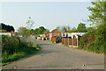
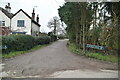
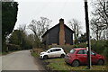
Ivy Hatch Residential Site
Formerly known as Green Lane Gypsy Site, it was founded in 1964 by Godstone Rural District Council, and is now owned by Tandridge District Council.
Image: © Ian Capper
Taken: 25 Apr 2011
0.22 miles