IMAGES TAKEN NEAR TO
Masons Bridge Road, REDHILL, RH1 5JU
Introduction
This page details the photographs taken nearby to Masons Bridge Road, RH1 5JU by members of the Geograph project.
The Geograph project started in 2005 with the aim of publishing, organising and preserving representative images for every square kilometre of Great Britain, Ireland and the Isle of Man.

There are currently over 7.5m images from over14,400 individuals and you can help contribute to the project by visiting https://www.geograph.org.uk
Image Map
Images are licensed for reuse under creativecommons.org/licenses/by-sa/2.0
Notes
- Clicking on the map will re-center to the selected point.
- The higher the marker number, the further away the image location is from the centre of the postcode.
Image Listing (21 Images Found)
Images are licensed for reuse under creativecommons.org/licenses/by-sa/2.0
Image
Details
Distance
1
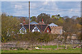
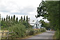
Honeycrock Farm
This castellated house caused controversy after it was built in around 2002 without planning permission, having been concealed behind hay bales which were only removed in 2006. Although the owner had argued that by 4 year gap meant that the need for planning permission had passed, the counter argument was put that the hay bales constituted an integral part of the construction process, and so the building was therefore not completed until 2006. Demolition of the property was ordered, and the local council's view was ratified by the High Court when the case went to appeal.
For one press report see http://www.telegraph.co.uk/news/uknews/7145967/A-farmer-who-secretly-built-castle-behind-straw-bales-ordered-to-demolish-it.html and for the council's statement see http://81.150.212.1/planning/planning_enforcement/honeycrockfarm/.
Even so, the building is still in place in this 2012 photo.
Image: © Ian Capper
Taken: 22 Apr 2012
0.06 miles
5
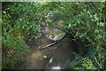
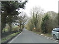
Mason's Bridge...looking North
Bridge carries Mason's Bridge Road over Salfords Stream. This stream flows West to join the River Mole.
Image: © Rib
Taken: 14 Jan 2006
0.09 miles

9
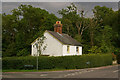
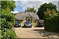
Rose Cottages
A pair of semi-detached cottages in Axes Lane, at its junction with Mason's Bridge Road, Picketts Lane and Honeycrock Lane.
Image: © Ian Capper
Taken: 19 Jun 2010
0.10 miles