IMAGES TAKEN NEAR TO
Bonehurst Road, REDHILL, RH1 5EP
Introduction
This page details the photographs taken nearby to Bonehurst Road, RH1 5EP by members of the Geograph project.
The Geograph project started in 2005 with the aim of publishing, organising and preserving representative images for every square kilometre of Great Britain, Ireland and the Isle of Man.

There are currently over 7.5m images from over14,400 individuals and you can help contribute to the project by visiting https://www.geograph.org.uk
Image Map
Images are licensed for reuse under creativecommons.org/licenses/by-sa/2.0
Notes
- Clicking on the map will re-center to the selected point.
- The higher the marker number, the further away the image location is from the centre of the postcode.
Image Listing (15 Images Found)
Images are licensed for reuse under creativecommons.org/licenses/by-sa/2.0
Image
Details
Distance

3

Fixings Center, Salfords
That's how they spell it, not me.
Image: © David Howard
Taken: 29 Mar 2015
0.07 miles
4

Mile Post
Set a bit too deep and subsiding!
Image: © The Saunterer
Taken: 19 Aug 2012
0.08 miles
5
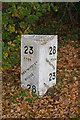
Old Milepost by the A23, Bonehurst Road, Salfords
Cast iron post by the A23, in parish of Salfords and Sidlow (Reigate and Banstead District), Bonehurst Road, Salfords, just North of "X Ray House", on the verge between pavement and ditch, on East side of road. Reigate iron casting, erected by the Horley Common to Cuckfield turnpike trust in the 19th century.
Inscription reads:-
: 23 / FROM / WESTMINSTER / BRIDGE / 28 / (TO / BRIGHTON) : : PARISH / OF / HORLEY : : 28 / FROM / BRIGHTON / 23 / TO / WESTM(INSTER / BRIDGE) :
Milestone Society National ID: SY_LBT23
Image: © JS Payne
Taken: 1 Sep 2007
0.09 miles
6
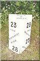
Milepost, Pear Tree Hill
Close up of the cast iron milepost in Image This of a standard design for mileposts along this route, which was built in 1816 as a direct route from Gatton Point, north of Redhill, to Povey Cross, near Gatwick.
The post shows the distances to/from Brighton and Westminster Bridge on the two faces, but in a different order according to the direction of travel. On the top face is the locality (here the Parish of Horley).
Image: © Ian Capper
Taken: 20 Nov 2011
0.09 miles
7
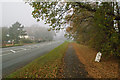
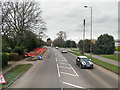
Pear Tree Hill
The A23 between Salfords and Horley is largely called Bonehurst Road, with the exception of a short stretch here where the name briefly changes to Pear Tree Hill. This was part of the turnpike south from Redhill dating from 1816. Note the milepost on the right - see Image for close up.
Image: © Ian Capper
Taken: 20 Nov 2011
0.10 miles
8
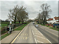
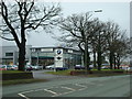
A23 Bonehurst Road
By the northbound Crossoak Lane bus stop.
Image: © Robin Webster
Taken: 23 Mar 2019
0.13 miles
9
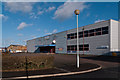
Salfords Industrial Estate
A unit in Salfords Industrial Estate off Bonehurst Road, housing a branch of Jewsons Builders Merchants.
Image: © Ian Capper
Taken: 27 Jan 2013
0.15 miles