IMAGES TAKEN NEAR TO
Shirley Avenue, REDHILL, RH1 5AJ
Introduction
This page details the photographs taken nearby to Shirley Avenue, RH1 5AJ by members of the Geograph project.
The Geograph project started in 2005 with the aim of publishing, organising and preserving representative images for every square kilometre of Great Britain, Ireland and the Isle of Man.

There are currently over 7.5m images from over14,400 individuals and you can help contribute to the project by visiting https://www.geograph.org.uk
Image Map
Images are licensed for reuse under creativecommons.org/licenses/by-sa/2.0
Notes
- Clicking on the map will re-center to the selected point.
- The higher the marker number, the further away the image location is from the centre of the postcode.
Image Listing (62 Images Found)
Images are licensed for reuse under creativecommons.org/licenses/by-sa/2.0
Image
Details
Distance
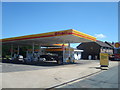
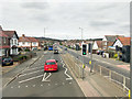
3
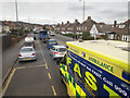
A23 Horley Road, South Earlswood
A queue up to traffic lights, where a right turn leads to the local large hospital, so ambulances are quite common here. An interesting attempt to drum up trade on the right, giving motorists a lot of small print to read to distract them from what they should be looking at.
Image: © Robin Webster
Taken: 23 Mar 2019
0.08 miles
6
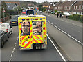
A23 Horley Road, South Earlswood
A queue up to traffic lights, where a right turn leads to the local large hospital, so ambulances are quite common here.
Image: © Robin Webster
Taken: 23 Mar 2019
0.08 miles
7
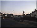
Hanworth Road at the junction of Horley Road
Image: © David Howard
Taken: 22 Jan 2017
0.08 miles
9
A23 Horley Road, South Earlswood
Heading north towards Redhill.
Image: © Robin Webster
Taken: 23 Mar 2019
0.09 miles
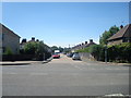
10
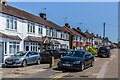
Prince Albert Square
c.1930s housing off Horley Road. The name derives from pub on the opposite side of Horley Road, originally the Prince Albert, now a McDonald's restaurant.
Image: © Ian Capper
Taken: 16 Jun 2021
0.11 miles