IMAGES TAKEN NEAR TO
Coulstock Road, BURGESS HILL, RH15 9XZ
Introduction
This page details the photographs taken nearby to Coulstock Road, RH15 9XZ by members of the Geograph project.
The Geograph project started in 2005 with the aim of publishing, organising and preserving representative images for every square kilometre of Great Britain, Ireland and the Isle of Man.

There are currently over 7.5m images from over14,400 individuals and you can help contribute to the project by visiting https://www.geograph.org.uk
Image Map
Images are licensed for reuse under creativecommons.org/licenses/by-sa/2.0
Notes
- Clicking on the map will re-center to the selected point.
- The higher the marker number, the further away the image location is from the centre of the postcode.
Image Listing (37 Images Found)
Images are licensed for reuse under creativecommons.org/licenses/by-sa/2.0
Image
Details
Distance
1
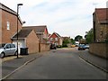
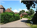
Coulstock Road, Burgess Hill
Part of the western expansion of the town since 1990s. Prior to that it was once a field called Hovel Mead according to Hurstpierpoint's 1842 tithe map.
Image: © Simon Carey
Taken: 25 Jul 2014
0.05 miles
2

Jane Murray Way
Crossing Jane Murray Way from the footpath.
Image: © Chris Thomas-Atkin
Taken: 5 Nov 2017
0.09 miles
3
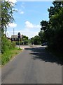
Malthouse Lane
The highway starts as College Lane in Hurstpierpoint then heads north changing to Malthouse Lane at the junction with Chalkers Lane next to Hurstpierpoint College. Originally the road headed eastwards and ended at the junction with West Street and Royal George Road. However, since the 1990s Burgess Hill has extended westwards into the old parish of Hurstpierpoint, a new bypass, the jane Murray Way, was built and new housing estates sprung up on the eastern side of it. As a consequence, Malthouse Lane as a through road, ends on the bypass, though it continues eastward beyond.
Image: © Simon Carey
Taken: 25 Jul 2014
0.10 miles
4

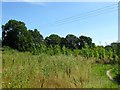
Pook Bourne Stream
The Pook Bourne Stream running West from Burgess Hill.
Image: © Chris Thomas-Atkin
Taken: 5 Nov 2017
0.11 miles
5
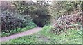
Path to the Pook Bourne Stream
The path to the left drops to a small ford on the Pook Bourne Stream.
Image: © Chris Thomas-Atkin
Taken: 5 Nov 2017
0.11 miles
6
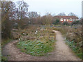
The Green Crescent
Part of Burgess Hill's attempt to provide public access to green areas on the edge of town. The crescent runs from Bedelands Farm nature reserve in the north then follows the western border of the town to Batchelors Farm nature reserve in the south. The access includes bridleways, footpaths and open access land. Here the bridleway drops to the left to ford Pook Bourne whilst the footpath runs over it to the right. Beyond is Jane Murray Way, the A273, a bypass built in the late 1990s, followed by the western edge of the town itself. The scheme was set up around 2003 and implemented over the past couple of years, the bridleway surface was laid in November.
Image: © Simon Carey
Taken: 4 Jan 2009
0.11 miles
7
Seven Fields, Burgess Hill
The name of the cul de sac that runs off Malthouse Lane which was built during the 1990s. The estate is located within a former field called Upper Cow Pasture according to Hurstpierpoint's 1842 tithe map and the old shape of the field can still be made out by the trees that have been left standing in aerial photographs.
Image: © Simon Carey
Taken: 25 Jul 2014
0.13 miles
8
Shoulder of Mutton
The name of the field according to Hurstpierpoint's 1842 tithe map that is now part of the Burgess Hill Green Circle Network a series of open spaces around the edge of the town open to the public. The field, named after its shape, is wedged between Malthouse lane to the west and north, Pook Bourne to the south and the jane Murray Way, the A273, to the east. It is in the process of being planted.
Image: © Simon Carey
Taken: 22 Jul 2014
0.13 miles
9
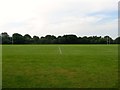
Southway Recreation Ground, Burgess Hill
Home since 1970 of Burgess Hill Rugby Football Club. Their clubhouse is out of shot to the left and access is made through Image
Image: © Simon Carey
Taken: 25 Jul 2014
0.13 miles
10
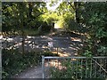
Crossing Malthouse Lane
Preparing to cross the lane on the Burgess Hill Green Circle Network. See https://www.burgesshill.gov.uk/greencircle
Image: © Chris Thomas-Atkin
Taken: 5 Aug 2018
0.14 miles