IMAGES TAKEN NEAR TO
Peartree Close, BURGESS HILL, RH15 9PF
Introduction
This page details the photographs taken nearby to Peartree Close, RH15 9PF by members of the Geograph project.
The Geograph project started in 2005 with the aim of publishing, organising and preserving representative images for every square kilometre of Great Britain, Ireland and the Isle of Man.

There are currently over 7.5m images from over14,400 individuals and you can help contribute to the project by visiting https://www.geograph.org.uk
Image Map
Images are licensed for reuse under creativecommons.org/licenses/by-sa/2.0
Notes
- Clicking on the map will re-center to the selected point.
- The higher the marker number, the further away the image location is from the centre of the postcode.
Image Listing (20 Images Found)
Images are licensed for reuse under creativecommons.org/licenses/by-sa/2.0
Image
Details
Distance
1
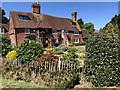
Old Timbers
The property nowadays known as Old Timbers on Westhill Drive. This was previously Fowles Farmhouse built around 1588.
Image: © Chris Thomas-Atkin
Taken: 5 Aug 2018
0.09 miles
2
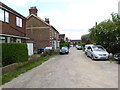
Industrial units on Victoria Road Burgess Hill
Image: © Dave Spicer
Taken: 7 Sep 2012
0.10 miles
3
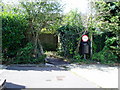
Twitten to Portland Road
Public Footpath 53bBH from Orchard Way.
Image: © Peter Holmes
Taken: 18 Jul 2009
0.11 miles
4
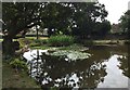
Pond at Old Timbers
The pond in the garden of Old Timbers, which is used by a local angling club.
Image: © Chris Thomas-Atkin
Taken: 11 Aug 2018
0.12 miles
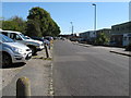
6
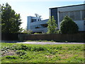
Modern looking industrial unit on the corner of Victoria Road and Victoria Gardens
In fact the building is nearly 25 years old, at the time of construction the roof was built on the floor and gradually raised, making it the largest expanse of roof built in this manner in Europe. The roof has skylight shutters which were rain sensitive and closed instantly at the first drop of rain.
Image: © Dave Spicer
Taken: 7 Sep 2012
0.16 miles
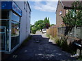
7
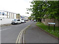
Looking eastwards into Victoria Road
The OS maps this as Victoria Close.
Image: © Shazz
Taken: 24 May 2016
0.17 miles

10
Portland Road
Public Footpath 53aBH leading Orchard Way.
Image: © Peter Holmes
Taken: 18 Jul 2009
0.20 miles