IMAGES TAKEN NEAR TO
Chanctonbury Road, BURGESS HILL, RH15 9HN
Introduction
This page details the photographs taken nearby to Chanctonbury Road, RH15 9HN by members of the Geograph project.
The Geograph project started in 2005 with the aim of publishing, organising and preserving representative images for every square kilometre of Great Britain, Ireland and the Isle of Man.

There are currently over 7.5m images from over14,400 individuals and you can help contribute to the project by visiting https://www.geograph.org.uk
Image Map
Images are licensed for reuse under creativecommons.org/licenses/by-sa/2.0
Notes
- Clicking on the map will re-center to the selected point.
- The higher the marker number, the further away the image location is from the centre of the postcode.
Image Listing (21 Images Found)
Images are licensed for reuse under creativecommons.org/licenses/by-sa/2.0
Image
Details
Distance
1
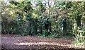
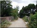
Path Junction
A junction of paths close to the railway line, which lies in a cutting just behind the fencing and tree cover.
Image: © Chris Thomas-Atkin
Taken: 5 Nov 2017
0.12 miles
2
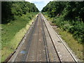
The line to London
Just visible is Burgess Hill Station.
Image: © Dave Spicer
Taken: 24 Jul 2011
0.12 miles
3
Green Lane
Approaching its junction with Sunset Lane
Image: © Peter Jeffery
Taken: 1 Mar 2007
0.14 miles
4
Down train from Burgess Hill approaches bridge carrying bridleway
See also http://www.geograph.org.uk/photo/2524455.
Image: © Shazz
Taken: 22 Jun 2016
0.15 miles
5
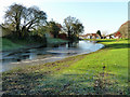
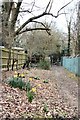
Flooded amenity land
A scrap of open space, only accessible from Potters Lane in the distance. Its propensity to flood may be the reason it has been left undeveloped. Frost persists in the shade, and the water is lightly iced over.
Image: © Robin Webster
Taken: 26 Nov 2010
0.16 miles
6
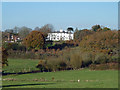
Franklands Court
This well-positioned house started out as Franklands and passed through similar names until the Franklands Court of today. It was also briefly called the Burgess Hill Hydro prior to the First World War.
Image: © Robin Webster
Taken: 26 Nov 2010
0.17 miles
7
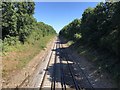
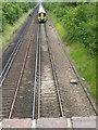
Towards Burgess Hill
Looking northwards along the Brighton to London railway line in the direction of Burgess Hill Station.
Image: © Chris Thomas-Atkin
Taken: 5 Aug 2018
0.18 miles
8
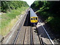
First Capital Connect service to Brighton
Looking north towards Burgess Hill station.
Image: © Peter Holmes
Taken: 18 Jul 2009
0.19 miles
9
Bridge across Brighton Mainline at Batchelors Farm/Nightingale Lane Meadows
This view looks towards Nightingale Meadows in the south of Burgess Hill. Behind the photographer is Batchelors Farm.
Image: © Curtis Bateman
Taken: 29 Jul 2010
0.20 miles
10
Roman road marker, Nightingale Lane
The short roughly north-south part of this road is on the alignment of Roman road 150. This marker is set in the pavement tarmac. There are others marking the line elsewhere in Burgess Hill.
Image: © Robin Webster
Taken: 26 Nov 2010
0.21 miles