IMAGES TAKEN NEAR TO
Alice Court, BURGESS HILL, RH15 9ET
Introduction
This page details the photographs taken nearby to Alice Court, RH15 9ET by members of the Geograph project.
The Geograph project started in 2005 with the aim of publishing, organising and preserving representative images for every square kilometre of Great Britain, Ireland and the Isle of Man.

There are currently over 7.5m images from over14,400 individuals and you can help contribute to the project by visiting https://www.geograph.org.uk
Image Map
Images are licensed for reuse under creativecommons.org/licenses/by-sa/2.0
Notes
- Clicking on the map will re-center to the selected point.
- The higher the marker number, the further away the image location is from the centre of the postcode.
Image Listing (28 Images Found)
Images are licensed for reuse under creativecommons.org/licenses/by-sa/2.0
Image
Details
Distance
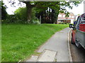
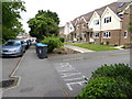
3
Tree and footbridge by Charles Avenue
This area provides a welcome break in amongst all the business premises.
Image: © Shazz
Taken: 24 May 2016
0.09 miles
5

Forest View, Southway, Burgess Hill
A purpose built care home run by Shaw Healthcare at the southern end of Southway. Prior to that the building was called Shelleys and was a children's home from the 1960s up until its demolition in 2005.
Image: © Simon Carey
Taken: 25 Jul 2014
0.12 miles
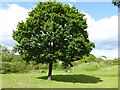
7
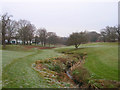
Pook Bourne
A small stream that rises not far from here and is a tributary of Herrings Stream joining that watercourse east of Hickstead. The park provides a small area of greenery amidst the Victoria Business Park, the older units being to the east and the newer ones to the west.
Image: © Simon Carey
Taken: 4 Jan 2009
0.15 miles
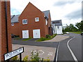
8
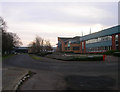
Charles Avenue, Victoria Business Park
At the point where York Road turns 90 degrees to become Charles Road. The former was added as an access route when Jane Murray Way was constructed in the late 1990s.
Image: © Simon Carey
Taken: 4 Jan 2009
0.15 miles
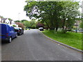
9

Southway, Burgess Hill
Heading south from Image the road was originally a farm track that was developed through the 1960s.
Image: © Simon Carey
Taken: 25 Jul 2014
0.15 miles
10
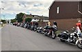
Prom Night
One lucky student was being taken to their Prom Night as a passenger on a Harley Davidson bike with an escort of 15 other bikes.
Image: © Chris Thomas-Atkin
Taken: 28 Jun 2018
0.16 miles