IMAGES TAKEN NEAR TO
Bluebird Walk, BURGESS HILL, RH15 9EL
Introduction
This page details the photographs taken nearby to Bluebird Walk, RH15 9EL by members of the Geograph project.
The Geograph project started in 2005 with the aim of publishing, organising and preserving representative images for every square kilometre of Great Britain, Ireland and the Isle of Man.

There are currently over 7.5m images from over14,400 individuals and you can help contribute to the project by visiting https://www.geograph.org.uk
Image Map
Images are licensed for reuse under creativecommons.org/licenses/by-sa/2.0
Notes
- Clicking on the map will re-center to the selected point.
- The higher the marker number, the further away the image location is from the centre of the postcode.
Image Listing (26 Images Found)
Images are licensed for reuse under creativecommons.org/licenses/by-sa/2.0
Image
Details
Distance
1
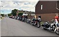
Prom Night
One lucky student was being taken to their Prom Night as a passenger on a Harley Davidson bike with an escort of 15 other bikes.
Image: © Chris Thomas-Atkin
Taken: 28 Jun 2018
0.08 miles
2
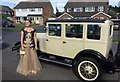
Vintage Car
A Vintage Car, an Essex makes an appearance in Victoria Avenue during the Prom Season.
Image: © Chris Thomas-Atkin
Taken: 1 Jul 2016
0.08 miles
3
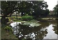
Pond at Old Timbers
The pond in the garden of Old Timbers, which is used by a local angling club.
Image: © Chris Thomas-Atkin
Taken: 11 Aug 2018
0.09 miles
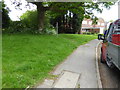
6

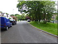
Southway, Burgess Hill
Heading south from Image the road was originally a farm track that was developed through the 1960s.
Image: © Simon Carey
Taken: 25 Jul 2014
0.11 miles
7
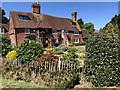
Old Timbers
The property nowadays known as Old Timbers on Westhill Drive. This was previously Fowles Farmhouse built around 1588.
Image: © Chris Thomas-Atkin
Taken: 5 Aug 2018
0.12 miles
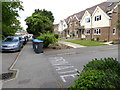
8

Forest View, Southway, Burgess Hill
A purpose built care home run by Shaw Healthcare at the southern end of Southway. Prior to that the building was called Shelleys and was a children's home from the 1960s up until its demolition in 2005.
Image: © Simon Carey
Taken: 25 Jul 2014
0.12 miles
9
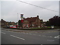
"The Weald" public house, Burgess Hill, Sussex
A large pub serving a newer area of the town
Image: © Dr Neil Clifton
Taken: 5 Oct 2005
0.12 miles