IMAGES TAKEN NEAR TO
Foxglove Close, BURGESS HILL, RH15 8UY
Introduction
This page details the photographs taken nearby to Foxglove Close, RH15 8UY by members of the Geograph project.
The Geograph project started in 2005 with the aim of publishing, organising and preserving representative images for every square kilometre of Great Britain, Ireland and the Isle of Man.

There are currently over 7.5m images from over14,400 individuals and you can help contribute to the project by visiting https://www.geograph.org.uk
Image Map
Images are licensed for reuse under creativecommons.org/licenses/by-sa/2.0
Notes
- Clicking on the map will re-center to the selected point.
- The higher the marker number, the further away the image location is from the centre of the postcode.
Image Listing (31 Images Found)
Images are licensed for reuse under creativecommons.org/licenses/by-sa/2.0
Image
Details
Distance
1
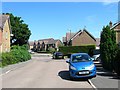
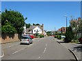
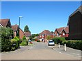
Foxglove Close, Burgess Hill
Part of the housing estate built after the construction of the bypass in the late 1990s.
Image: © Simon Carey
Taken: 22 Jul 2014
0.06 miles
2
Shelley Wood
The small development of houses known as Shelley Wood.
Image: © Chris Thomas-Atkin
Taken: 5 Aug 2018
0.07 miles
3
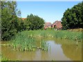
Pond, Primrose close, Burgess Hill
An old pond that predates the estate it now forms part of.
Image: © Simon Carey
Taken: 22 Jul 2014
0.08 miles
4
The Maltings, Burgess Hill
A cul de sac off Image that was built in the 1990s. Both roads lie within an old field called Pear Tree Field according to Hurstpierpoint's 1842 tithe whose outline can still be made out by the former hedgerow trees that were left standing.
Image: © Simon Carey
Taken: 25 Jul 2014
0.11 miles
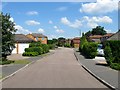
5
The Oaks, Burgess Hill
Part of a large housing development built within the confines of a new bypass from the late 1990s. Once part of a field called Flat Four Acres according to Hurstpierpoint's 1842 tithe map.
Image: © Simon Carey
Taken: 22 Jul 2014
0.11 miles
6
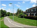
Cycle Path and Footway, Burgess Hill
Linking Gatehouse Lane to Bramble Gardens. The houses on the right front onto Image
Image: © Simon Carey
Taken: 25 Jul 2014
0.11 miles
7
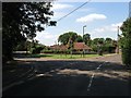
Gatehouse Lane, Burgess Hill
Looking towards the junction with Malthouse Lane. Between the two lanes and the former parish boundary separating Clayton from Hurstpierpoint was Shelley's Wood, whose northern part adjacent to Gatehouse Lane was built upon during the 1930s with the rest of it to the south developed during the 1960s becoming for a time the western end of Burgess Hill, until that too was extended further westwards in the 1990s. Gatehouse Lane was also the old route used by those from the town wishing to join the A23 following a number of country roads, Bishopstone Lane and Job's Lane to Hickstead. This too was replaced by the construction of the A2300 in 1997.
Image: © Simon Carey
Taken: 25 Jul 2014
0.11 miles
8
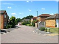
Barley Drive, Burgess Hill
Residential road linking Coulstock Road to Image and occupying a former field called Pear Tree Field according to Hurstpierpoint's 1842 tithe map, whose hedgerow trees remain in situ and whose shape can still be determined on aerial photographs.
Image: © Simon Carey
Taken: 25 Jul 2014
0.14 miles
9
The Rowans, Burgess Hill
Small cul de sac off The Acorns and part of a large area of housing constructed from the late 1990s onwards within the boundaries of a new bypass.
Image: © Simon Carey
Taken: 22 Jul 2014
0.15 miles
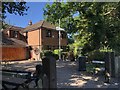
10
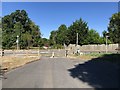
Approaching Jane Murray Way
Gatehouse Lane is split by Jane Murray Way. The lane had previously been a major route out of Burgess Hill.
Image: © Chris Thomas-Atkin
Taken: 5 Aug 2018
0.16 miles