IMAGES TAKEN NEAR TO
Berry Close, BURGESS HILL, RH15 8SD
Introduction
This page details the photographs taken nearby to Berry Close, RH15 8SD by members of the Geograph project.
The Geograph project started in 2005 with the aim of publishing, organising and preserving representative images for every square kilometre of Great Britain, Ireland and the Isle of Man.

There are currently over 7.5m images from over14,400 individuals and you can help contribute to the project by visiting https://www.geograph.org.uk
Image Map
Images are licensed for reuse under creativecommons.org/licenses/by-sa/2.0
Notes
- Clicking on the map will re-center to the selected point.
- The higher the marker number, the further away the image location is from the centre of the postcode.
Image Listing (35 Images Found)
Images are licensed for reuse under creativecommons.org/licenses/by-sa/2.0
Image
Details
Distance
1
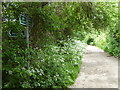
Freek's Lane goes north from footpath junction
Image: © Shazz
Taken: 24 May 2016
0.05 miles
2
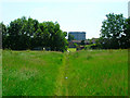
Footpath to Fairplace Hill
Skirting the northern edge of Burgess Hill. The path originally connected Freek's Lane to Chapel Farm.
Image: © Simon Carey
Taken: 9 Apr 2015
0.06 miles
3
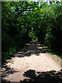
Freek's Lane
Unmade lane serving Freek's Farm and Lowlands Farm. It also carries the footpath from Leylands Road to Isaacs Lane.
Image: © Simon Carey
Taken: 8 Jun 2008
0.12 miles
4
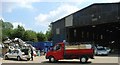
Burgess Hill Dump
Sunday afternoon at the local tip! Burgess Hill has a household waste disposal site on the N edge of the town. The site operates a system where different types of refuse are separated. On the left, a pile of scrap metal can be seen. Out of shot are separate areas for paper items and garden rubbish (amongst other types). "General" waste (e.g. old furniture etc) is deposited in the large shed for further sorting by the facilities staff.
Image: © Pete Chapman
Taken: 10 Jul 2005
0.13 miles
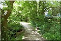
5
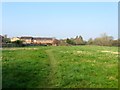
Footpath Entering Burgess Hill
This is the northern edge of the town. The town was built on the former St John's Common and has been extending its boundaries ever since, the housing estate in the background being built in the 1980s. The gasometer is in Leylands Road and marked a previous northern boundary of the town.
Image: © Simon Carey
Taken: 8 Jun 2008
0.13 miles
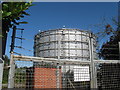
9
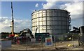
Demolition of the Gas Holder
Demolition work has just started on taking down the old Gas Holder by Leylands Road. This is to make way for a Super Store that is being relocated as part of the planned £65m redevelopment of Burgess Hill Town Centre.
Image: © Chris Thomas-Atkin
Taken: 1 Sep 2017
0.15 miles
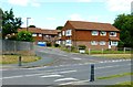
10
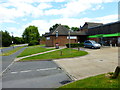
Looking east on Maple Drive past the "Co-op"
Image: © Shazz
Taken: 14 Jul 2014
0.15 miles