IMAGES TAKEN NEAR TO
RH15 8RH
Introduction
This page details the photographs taken nearby to RH15 8RH by members of the Geograph project.
The Geograph project started in 2005 with the aim of publishing, organising and preserving representative images for every square kilometre of Great Britain, Ireland and the Isle of Man.

There are currently over 7.5m images from over14,400 individuals and you can help contribute to the project by visiting https://www.geograph.org.uk
Image Map
Images are licensed for reuse under creativecommons.org/licenses/by-sa/2.0
Notes
- Clicking on the map will re-center to the selected point.
- The higher the marker number, the further away the image location is from the centre of the postcode.
Image Listing (182 Images Found)
Images are licensed for reuse under creativecommons.org/licenses/by-sa/2.0
Image
Details
Distance
1
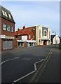
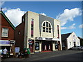
Orion Cinema, Cyprus Road
Built in 1928 on the site of the original cinema in the town which had opened prior to World War One. The cinema has survived over the years being refurbished in 1990 to include two screens and changing back to its original name in 1995 having also been known as the Scala. The white building next door is a Salvation Army hall. Cyprus Road leads off Church Road, the main shopping street, and links Mill Road in a one way system.
Image: © Simon Carey
Taken: 2 Mar 2008
0.01 miles
2
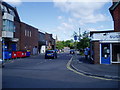
Public Footpath 58BH on Crescent Way
Route to Middle Way.
Image: © Peter Holmes
Taken: 18 Jul 2009
0.01 miles
3
Orion Cinema and Salvation Army Hall on Cyprus Road Burgess Hill
Image: © Dave Spicer
Taken: 7 Sep 2012
0.02 miles
4
Overflow car park
Route of public footpath 58BH crossing open space between Crescent Way and Middle Way.
Image: © Peter Holmes
Taken: 18 Jul 2009
0.02 miles
5
Burgess Hill: Orion Cinema, Cyprus Road
Image: © Dr Neil Clifton
Taken: 18 Sep 2012
0.04 miles
6
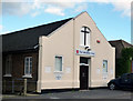
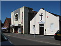
Burgess Hill: Salvation Army citadel, Cyprus Road
Image: © Dr Neil Clifton
Taken: 18 Sep 2012
0.04 miles
7
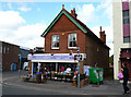
Burgess Hill: 'Fancy That', Cyprus Road
Burgess Hill's answer to Auntie Wainwright's
Image: © Dr Neil Clifton
Taken: 18 Sep 2012
0.04 miles
8
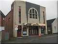
Orion Cinema - Burgess Hill
located in Cyprus Road
Image: © Paul Gillett
Taken: 20 Nov 2010
0.05 miles
9
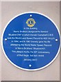
Norris Brothers Bluebird Plaque
The plaque on the outside of a building in Church Walk Burgess Hill. It marks the place where the Norris brothers designed the famous Bluebird in which Donald Campbell tragically lost his life in 1967. The plaque was installed to mark the 50th anniversary of his death.
Image: © Chris Thomas-Atkin
Taken: 11 Mar 2017
0.06 miles
10
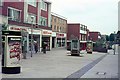
Church Walk
Looking north west from the junction with Cyprus Road.
Image: © Peter Jeffery
Taken: Unknown
0.06 miles