IMAGES TAKEN NEAR TO
The Blackthorns, BURGESS HILL, RH15 8HW
Introduction
This page details the photographs taken nearby to The Blackthorns, RH15 8HW by members of the Geograph project.
The Geograph project started in 2005 with the aim of publishing, organising and preserving representative images for every square kilometre of Great Britain, Ireland and the Isle of Man.

There are currently over 7.5m images from over14,400 individuals and you can help contribute to the project by visiting https://www.geograph.org.uk
Image Map
Images are licensed for reuse under creativecommons.org/licenses/by-sa/2.0
Notes
- Clicking on the map will re-center to the selected point.
- The higher the marker number, the further away the image location is from the centre of the postcode.
Image Listing (51 Images Found)
Images are licensed for reuse under creativecommons.org/licenses/by-sa/2.0
Image
Details
Distance
1
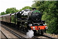
Approaching Wivelsfield
Black Five No.44871, with the Steam Dreams excursion to Eastbourne and Hastings.
Image: © Peter Trimming
Taken: 22 Jun 2019
0.10 miles
2
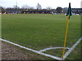
Leylands Park - Burgess Hill Town FC
The Hillians were playing Folkestone. The stadium is on the edge of town up a narrow road to a car park. It is bordered on one side by woodland.
Image: © nick macneill
Taken: 24 Jan 2009
0.10 miles
4
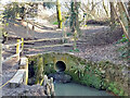
Drain emerging into woodland, Bedelands Farm local nature reserve
Image: © Robin Webster
Taken: 18 Mar 2022
0.11 miles
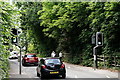
5
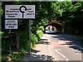
Railway Bridge, Leylands Road, Worlds End
The bridge carries the London-Brighton line over this busy minor road as well as the platforms of Wivelsfield station. The latter is a bit of an anomaly, being over 2 miles from the village and outside the parish boundary. It was a late addition to the line opening in 1886 to replace a station on the branch to Lewes. For the first 10 years it was known as Keymer Junction before changing to its current name in 1896.
Image: © Simon Carey
Taken: 8 Jun 2008
0.11 miles
6
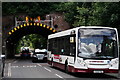
Wivelsfield
Bus outside the railway station, Leylands Road.
Image: © Peter Trimming
Taken: 22 Jun 2019
0.12 miles
7
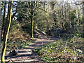
Path in Long Wood, Bedelands Farm local nature reserve
Heading out of the reserve towards the residential Coopers Close.
Image: © Robin Webster
Taken: 18 Mar 2022
0.12 miles
8
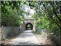
Rail Bridge near Wivelsfield station
The bridge carries the main London Line between Burgess Hill and Wivelsfield Station
Image: © Paul Gillett
Taken: 31 Jul 2014
0.12 miles
10
Maple Drive
Taken from the junction with Leylands Park, this part was built in the 1970s which originally made the estate a cul-de-sac, the extension to London Road was filled in the 1980s.
Image: © Simon Carey
Taken: 8 Jun 2008
0.12 miles