IMAGES TAKEN NEAR TO
Franks Close, BURGESS HILL, RH15 8GP
Introduction
This page details the photographs taken nearby to Franks Close, RH15 8GP by members of the Geograph project.
The Geograph project started in 2005 with the aim of publishing, organising and preserving representative images for every square kilometre of Great Britain, Ireland and the Isle of Man.

There are currently over 7.5m images from over14,400 individuals and you can help contribute to the project by visiting https://www.geograph.org.uk
Image Map
Images are licensed for reuse under creativecommons.org/licenses/by-sa/2.0
Notes
- Clicking on the map will re-center to the selected point.
- The higher the marker number, the further away the image location is from the centre of the postcode.
Image Listing (7 Images Found)
Images are licensed for reuse under creativecommons.org/licenses/by-sa/2.0
Image
Details
Distance
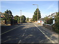
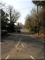
2
Looking across West Street to Downs Road, Burgess Hill
Downs Road is a cul-de-sac, leads to St John's Common.
Image: © Ruth Sharville
Taken: 26 Sep 2023
0.18 miles
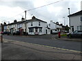
3
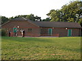
West End Meadows pavilion
West End Meadows Pavilion (The Brooks), Burgess Hill, owned by Mid Sussex District Council.
Image: © David Cumberland
Taken: 7 Jul 2008
0.21 miles
5
London Road, Burgess Hill
Currently the B2036 heading north from the junction with the A273 which until 1991 was the designation of this road. The highway itself is sometimes known as Fairplace Hill.
Image: © Simon Carey
Taken: 9 Apr 2015
0.25 miles
6
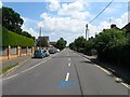
West Street, Burgess Hill
Originally an old track that ran across the Clayton portion of St John's Common which was straightened when it was enclosed in the 1850s. As the town grew the housing gradually expanded westwards reaching the junction with Royal George Road, another highway created by the enclosure of the common, around the 1950s.
Image: © Simon Carey
Taken: 25 Jul 2014
0.25 miles
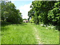
7
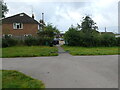
Path from St John's Common to Commercial Road
Image: © Ruth Sharville
Taken: 26 Sep 2023
0.25 miles