IMAGES TAKEN NEAR TO
Maple Drive, BURGESS HILL, RH15 8DJ
Introduction
This page details the photographs taken nearby to Maple Drive, RH15 8DJ by members of the Geograph project.
The Geograph project started in 2005 with the aim of publishing, organising and preserving representative images for every square kilometre of Great Britain, Ireland and the Isle of Man.

There are currently over 7.5m images from over14,400 individuals and you can help contribute to the project by visiting https://www.geograph.org.uk
Image Map
Images are licensed for reuse under creativecommons.org/licenses/by-sa/2.0
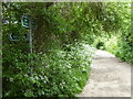
Notes
- Clicking on the map will re-center to the selected point.
- The higher the marker number, the further away the image location is from the centre of the postcode.
Image Listing (54 Images Found)
Images are licensed for reuse under creativecommons.org/licenses/by-sa/2.0
Image
Details
Distance
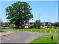
1
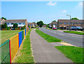
Maple Drive
Housing estate built on the northern edge of town in the 1980s.
Image: © Simon Carey
Taken: 8 Jun 2008
0.02 miles
2
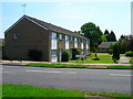
Maple Drive
Housing estate built in the 1980s on the northern edge of the town. The terraces have been built at angles to the road to give each a small garden with garages provided at the rear.
Image: © Simon Carey
Taken: 8 Jun 2008
0.03 miles
3
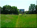
Footpath Entering Burgess Hill
This is the northern edge of the town. The town was built on the former St John's Common and has been extending its boundaries ever since, the housing estate in the background being built in the 1980s. The gasometer is in Leylands Road and marked a previous northern boundary of the town.
Image: © Simon Carey
Taken: 8 Jun 2008
0.05 miles
4
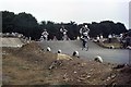
BMX Racing
The Burgess Hill tack was constructed by volunteers, using donated materials and equipment.
Image: © Peter Jeffery
Taken: Unknown
0.08 miles
5
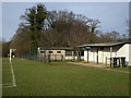
Southdown FC hut, Burgess Hill
These pitches are used for a local youth side, Southdown FC and for Sunday teams. They are close to Burgess Hill Town's ground at Leylands Park.
Image: © nick macneill
Taken: 24 Jan 2009
0.10 miles
6
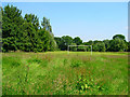
Football Pitch
On the northern edge of Burgess Hill, the pitch has been made on former common ground and will no doubt be the site of a housing estate in the future if the past history of the town is anything to go by.
Image: © Simon Carey
Taken: 8 Jun 2008
0.10 miles
7
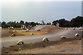
BMX Racing
The Burgess Hill track was constructed by volunteers using donated materials and equipment.
Image: © Peter Jeffery
Taken: Unknown
0.11 miles
8
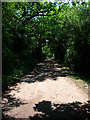
Freek's Lane
Unmade lane serving Freek's Farm and Lowlands Farm. It also carries the footpath from Leylands Road to Isaacs Lane.
Image: © Simon Carey
Taken: 8 Jun 2008
0.12 miles
9
Freek's Lane goes north from footpath junction
Image: © Shazz
Taken: 24 May 2016
0.12 miles
10
Maple Drive
Taken from the junction with Leylands Park, this part was built in the 1970s which originally made the estate a cul-de-sac, the extension to London Road was filled in the 1980s.
Image: © Simon Carey
Taken: 8 Jun 2008
0.12 miles