IMAGES TAKEN NEAR TO
Leylands Road, BURGESS HILL, RH15 8AB
Introduction
This page details the photographs taken nearby to Leylands Road, RH15 8AB by members of the Geograph project.
The Geograph project started in 2005 with the aim of publishing, organising and preserving representative images for every square kilometre of Great Britain, Ireland and the Isle of Man.

There are currently over 7.5m images from over14,400 individuals and you can help contribute to the project by visiting https://www.geograph.org.uk
Image Map
Images are licensed for reuse under creativecommons.org/licenses/by-sa/2.0
Notes
- Clicking on the map will re-center to the selected point.
- The higher the marker number, the further away the image location is from the centre of the postcode.
Image Listing (22 Images Found)
Images are licensed for reuse under creativecommons.org/licenses/by-sa/2.0
Image
Details
Distance
2
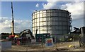
Demolition of the Gas Holder
Demolition work has just started on taking down the old Gas Holder by Leylands Road. This is to make way for a Super Store that is being relocated as part of the planned £65m redevelopment of Burgess Hill Town Centre.
Image: © Chris Thomas-Atkin
Taken: 1 Sep 2017
0.06 miles
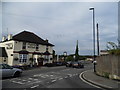
4
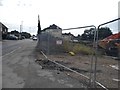
Leylands Road, Burgess Hill
The site on the right is where the gasholders have just been cleared away.
Image: © David Howard
Taken: 9 Aug 2018
0.06 miles
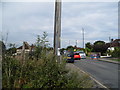
5
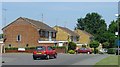
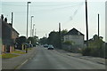
1980s Housing at Leylands Park, Burgess Hill
Burgess Hill has expanded continuously, since the railway first arrived in the nineteenth century. Here we see a typical selection of 1980s built houses built as part of a large estate on the N side of the town.
Image: © Pete Chapman
Taken: 10 Jul 2005
0.07 miles
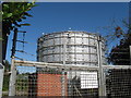
6
Gasometer in Leylands Road
Behind the Windmill Pub this gasometer is a familiar sight which may be replaced by housing in the future.
Image: © Nigel Freeman
Taken: 12 Jul 2005
0.08 miles
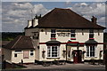
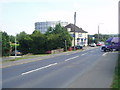
8
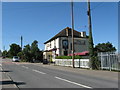
The Windmill on Leylands Road
On the far side of the pub is Freek's Lane.
Image: © Dave Spicer
Taken: 7 Sep 2012
0.11 miles