IMAGES TAKEN NEAR TO
Johnson Drive, BURGESS HILL, RH15 0TT
Introduction
This page details the photographs taken nearby to Johnson Drive, RH15 0TT by members of the Geograph project.
The Geograph project started in 2005 with the aim of publishing, organising and preserving representative images for every square kilometre of Great Britain, Ireland and the Isle of Man.

There are currently over 7.5m images from over14,400 individuals and you can help contribute to the project by visiting https://www.geograph.org.uk
Image Map
Images are licensed for reuse under creativecommons.org/licenses/by-sa/2.0
Notes
- Clicking on the map will re-center to the selected point.
- The higher the marker number, the further away the image location is from the centre of the postcode.
Image Listing (35 Images Found)
Images are licensed for reuse under creativecommons.org/licenses/by-sa/2.0
Image
Details
Distance
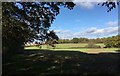
1
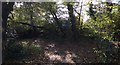
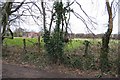
Path Junction
The footpath from Ote Hall Farm meets with a bridleway on the outskirts of Burgess Hill.
Image: © Chris Thomas-Atkin
Taken: 5 Nov 2017
0.02 miles
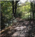
2
Footpath branching away bridleway on edge of Burgess Hill
Image: © Dave Spicer
Taken: 15 May 2011
0.03 miles
4
Footpath to Kings Way
The footpath links up to the bridleway that begins on nearby Manor Road and heads south to Ditchling Common. The fence marks the eastern edge of Burgess Hill.
Image: © Simon Carey
Taken: 28 Aug 2009
0.05 miles
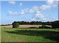
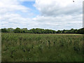
5
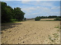
Burgess Hill from One O'clock Lane
Burgess Hill is spreading across the green fields, soon to reach Ditchling Common.
Image: © Peter Jeffery
Taken: 1 Mar 2008
0.08 miles
6
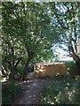
Property fence around the most easterly house in Burgess Hill
Image: © Dave Spicer
Taken: 15 May 2011
0.08 miles
7
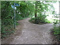
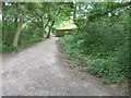
Path Junction in Sunshine
Autumn sunshine lights up the path junction with a new looking finger post in place.
Image: © Chris Thomas-Atkin
Taken: 5 Nov 2017
0.08 miles
8
Knaves Acre
The name of the field according to the 1843 tithe map and formerly part of Frankbarrow, a medieval deer park that was disparked and enclosed in the 16th century. The triangular field bounded on its northern edge by a stream now lies next to the eastern edge of Burgess Hill. A footpath heads off to the Janes Lane on the right being illegally ridden on by a pensioner on a bicycle.
Image: © Simon Carey
Taken: 28 Aug 2009
0.08 miles
9
Fields near to Burgess Hill
Paths from nearby Burgess Hill head out across the fields towards Ote Hall Farm.
Image: © Chris Thomas-Atkin
Taken: 5 Nov 2017
0.10 miles
10
Four Acres
The name of this part of the field according to the 1843 tithe map. The modern enlarged field is an amalgamation of three; Four Acres, Two Acres and Nine Acres so I guess that makes it Fifteen Acres now. The wood on the left is Lovers Walk and that to the right The Capers. The area was once part of Frankbarrow, a medieval deer park that was disparked in the 1530s.
Image: © Simon Carey
Taken: 16 Aug 2009
0.12 miles