IMAGES TAKEN NEAR TO
Inholmes Park Road, BURGESS HILL, RH15 0JH
Introduction
This page details the photographs taken nearby to Inholmes Park Road, RH15 0JH by members of the Geograph project.
The Geograph project started in 2005 with the aim of publishing, organising and preserving representative images for every square kilometre of Great Britain, Ireland and the Isle of Man.

There are currently over 7.5m images from over14,400 individuals and you can help contribute to the project by visiting https://www.geograph.org.uk
Image Map
Images are licensed for reuse under creativecommons.org/licenses/by-sa/2.0
Notes
- Clicking on the map will re-center to the selected point.
- The higher the marker number, the further away the image location is from the centre of the postcode.
Image Listing (7 Images Found)
Images are licensed for reuse under creativecommons.org/licenses/by-sa/2.0
Image
Details
Distance
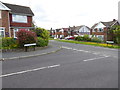
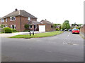
2
Looking over the hedge from Churchill Way to Oakwood Road
Image: © Shazz
Taken: 24 May 2016
0.11 miles
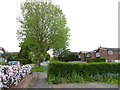
3
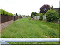
Drainage channel between Marlborough Drive and Alexandra Road
Image: © Shazz
Taken: 24 May 2016
0.12 miles
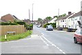
6
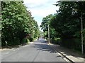
Silverdale Road
Looking eastwards towards the junction with Alexandra Road.
Image: © Curtis Bateman
Taken: 29 Jul 2010
0.23 miles
7
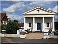
All Saints United Reformed Church, Junction Road
Taken from the opposite side of Junction Road, the road runs south to Hoadley's Corner and north towards World's End.
Image: © Curtis Bateman
Taken: 29 Jul 2010
0.25 miles