IMAGES TAKEN NEAR TO
Ferndale Road, BURGESS HILL, RH15 0HG
Introduction
This page details the photographs taken nearby to Ferndale Road, RH15 0HG by members of the Geograph project.
The Geograph project started in 2005 with the aim of publishing, organising and preserving representative images for every square kilometre of Great Britain, Ireland and the Isle of Man.

There are currently over 7.5m images from over14,400 individuals and you can help contribute to the project by visiting https://www.geograph.org.uk
Image Map
Images are licensed for reuse under creativecommons.org/licenses/by-sa/2.0
Notes
- Clicking on the map will re-center to the selected point.
- The higher the marker number, the further away the image location is from the centre of the postcode.
Image Listing (7 Images Found)
Images are licensed for reuse under creativecommons.org/licenses/by-sa/2.0
Image
Details
Distance
1
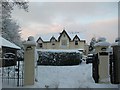
Wykeham, Birchwood Grove Road
Wykeham, a substantial residential property in Birchwood Grove Road, near to Birchwood Grove Primary School and Newick House School. Taken from end of driveway.
Image: © Curtis Bateman
Taken: 7 Jan 2010
0.06 miles
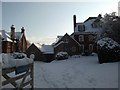
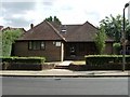
2
Birchwood Farm, Burgess Hill
Once a rural farm now a building stuck between two schools. In the background is the entrance to Newick House Special School whilst out of picture on the left hand side is Birchwood Grove Primary School.
Image: © Simon Carey
Taken: 24 Sep 2005
0.10 miles
3
Burgess Hill School For Girls
This building belongs to Burgess Hill School For Girls. The photo was taken on Silverdale Road.
Image: © Curtis Bateman
Taken: 7 Jan 2010
0.17 miles
4
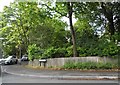
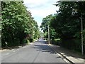
Folders Lane at the junction of Keymer Road
Image: © David Howard
Taken: 9 Aug 2018
0.18 miles
5
Silverdale Road
Looking eastwards towards the junction with Alexandra Road.
Image: © Curtis Bateman
Taken: 29 Jul 2010
0.19 miles
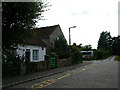
6
Silverdale Surgery, Silverdale Road
Doctors Surgery in Burgess Hill, in a partnership with Avenue Surgery on London Road. The surgery is headed by doctor Holwell.
Image: © Curtis Bateman
Taken: 29 Jul 2010
0.19 miles
7
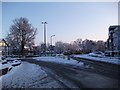
Hoadley's Corner
This roundabout is at Hoadley's Corner, a junction so named because of a department store that used to occupy the building to the left of this image. It is now more commonly known by locals as "the top of the town". Taken from Keymer Road (B2113) to Burgess Hill town centre. First exit is Junction Road, second exit to the immediate left of the mock tudor building is Silverdale Road, third exit is Keymer Road (B2113) towards Keymer.
Image: © Curtis Bateman
Taken: 7 Jan 2010
0.23 miles