IMAGES TAKEN NEAR TO
Farnlea, BURGESS HILL, RH15 0BD
Introduction
This page details the photographs taken nearby to Farnlea, RH15 0BD by members of the Geograph project.
The Geograph project started in 2005 with the aim of publishing, organising and preserving representative images for every square kilometre of Great Britain, Ireland and the Isle of Man.

There are currently over 7.5m images from over14,400 individuals and you can help contribute to the project by visiting https://www.geograph.org.uk
Image Map
Images are licensed for reuse under creativecommons.org/licenses/by-sa/2.0
Notes
- Clicking on the map will re-center to the selected point.
- The higher the marker number, the further away the image location is from the centre of the postcode.
Image Listing (31 Images Found)
Images are licensed for reuse under creativecommons.org/licenses/by-sa/2.0
Image
Details
Distance
1
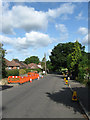
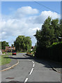
Manor Road, World's End
Heading down towards the recreation ground which can just be seen through the trees. The works are actually for the relaying of the pavement.
Image: © Simon Carey
Taken: 28 Aug 2009
0.08 miles
2
Janes Close, World's End
Small cul-de-sac off Janes Lane.
Image: © Simon Carey
Taken: 28 Aug 2009
0.09 miles
3
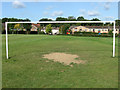
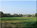
Lonely Goalpost, World's End Recreation Ground
A single goalpost lies between two marked pitches suggesting this set may well stay up throughout the year. Manor Court is to the right.
Image: © Simon Carey
Taken: 28 Aug 2009
0.10 miles
4
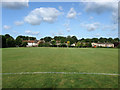
The Goalkeeper's View, World's End Recreation Ground
Looking down a slightly sloping pitch from the edge of the penalty area. Manor Court is to the right whilst the houses in Junction Road are to the left. The line of foliage in the background marks the course of the London-Brighton railway.
Image: © Simon Carey
Taken: 28 Aug 2009
0.10 miles
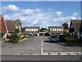
5
Ladymead, World's End
Small private housing estate off Janes Lane opposite World's End Recreation Ground.
Image: © Simon Carey
Taken: 28 Aug 2009
0.11 miles
6
Oakroyd Close, World's End
Small cul-de-sac off Janes Lane in the north eastern part of Burgess Hill.
Image: © Simon Carey
Taken: 28 Aug 2009
0.12 miles
7
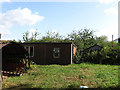
Awaiting Development, World's End
Small plot off Manor Road that has planning position for the construction of five houses. Looks like a former smallholding of some sort.
Image: © Simon Carey
Taken: 28 Aug 2009
0.15 miles
8
Theobalds Meadow (2)
The name of the field according to Wivelsfield's 1843 tithe map. This is the view south of the footpath which is also a county boundary thus putting this section in West Sussex since 1974. Part of the field was lost at the beginning of the 20th century to the houses and their gardens that were built on Janes Lane whilst those houses to the right belong to Oakroyd Close which was constructed in the 1960s. One wonders how long before this field is covered with a housing estate. See Image for a view of northern section.
Image: © Simon Carey
Taken: 17 Apr 2011
0.16 miles
9
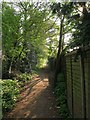
Footpath to Great Ote Hall
Predating the housing estates that have sprung up around it and since 1974 has been the boundary between East Sussex to the left and West Sussex to the right. However, the trees on the left are a remnant of an old field boundary that has remained intact particularly as the estate beyond it was still a field into the 1990s.
Image: © Simon Carey
Taken: 17 Apr 2011
0.17 miles
10
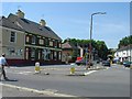
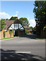
Watermill Inn, Worlds End, Burgess Hill, West Sussex
This view, taken looking WSW shows the Watermill Inn on the left. In the distance is a railway bridge, which is also the location of Wivelsfield Station (left of bridge).
Image: © Pete Chapman
Taken: 10 Jul 2005
0.18 miles