IMAGES TAKEN NEAR TO
Castle Street, REDHILL, RH1 4NU
Introduction
This page details the photographs taken nearby to Castle Street, RH1 4NU by members of the Geograph project.
The Geograph project started in 2005 with the aim of publishing, organising and preserving representative images for every square kilometre of Great Britain, Ireland and the Isle of Man.

There are currently over 7.5m images from over14,400 individuals and you can help contribute to the project by visiting https://www.geograph.org.uk
Image Map (Loading...)


Getting Data...Please wait
Leaflet Map data © OpenStreetMap
Images are licensed for reuse under creativecommons.org/licenses/by-sa/2.0
Notes
- Clicking on the map will re-center to the selected point.
- The higher the marker number, the further away the image location is from the centre of the postcode.
Image Listing (76 Images Found)
Images are licensed for reuse under creativecommons.org/licenses/by-sa/2.0
Image
Details
Distance
3
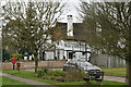
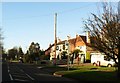
The Red Lion
The pub claims to be the oldest in the area, parts of the building dating from the early 14th century. It was originally known as the Maid.
Image: © Ian Capper
Taken: 9 May 2009
0.02 miles
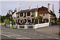
4
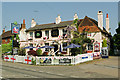
The Red Lion
The pub claims to be the oldest in the area, parts of the building dating from the early 14th century. It was originally known as the Maid. Decked in flags for St George's Day.
Image: © Ian Capper
Taken: 25 Apr 2011
0.02 miles
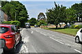
5
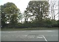
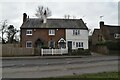
The A25 at the junction of Little Common Lane
The direction signs have vanished from the kerb opposite since 2012. Luckily the A25 goes due east to west so easier to know the likely choice than at most junctions.
Image: © David Howard
Taken: 29 Sep 2014
0.02 miles
7
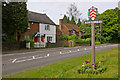
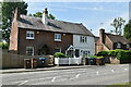
Castle Cottages and Mead Cottage
Castle Cottages are Victorian. Mead Cottage (on the right) is late 17th century.
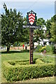
The village sign, unveiled in June 2008 and designed by the Rector of Bletchingley, the Revd Peter Moseling, shows the arms of the de Clare family (who owned the area following the Norman Conquest), surrounded by symbols representing the castle (now just earthworks), the church, timbered houses and woodland.
Image: © Ian Capper
Taken: 9 May 2009
0.05 miles