IMAGES TAKEN NEAR TO
Trindles Road, REDHILL, RH1 4JN
Introduction
This page details the photographs taken nearby to Trindles Road, RH1 4JN by members of the Geograph project.
The Geograph project started in 2005 with the aim of publishing, organising and preserving representative images for every square kilometre of Great Britain, Ireland and the Isle of Man.

There are currently over 7.5m images from over14,400 individuals and you can help contribute to the project by visiting https://www.geograph.org.uk
Image Map
Images are licensed for reuse under creativecommons.org/licenses/by-sa/2.0
Notes
- Clicking on the map will re-center to the selected point.
- The higher the marker number, the further away the image location is from the centre of the postcode.
Image Listing (79 Images Found)
Images are licensed for reuse under creativecommons.org/licenses/by-sa/2.0
Image
Details
Distance
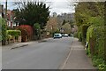
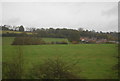
1
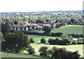
South Nutfield
This was taken looking down on the village from the Greensand Way. The wooded area to the south-east is part of the Low Weald.
Image: © David Kemp
Taken: 4 Oct 2006
0.01 miles