IMAGES TAKEN NEAR TO
Nutfield Road, REDHILL, RH1 4HB
Introduction
This page details the photographs taken nearby to Nutfield Road, RH1 4HB by members of the Geograph project.
The Geograph project started in 2005 with the aim of publishing, organising and preserving representative images for every square kilometre of Great Britain, Ireland and the Isle of Man.

There are currently over 7.5m images from over14,400 individuals and you can help contribute to the project by visiting https://www.geograph.org.uk
Image Map
Images are licensed for reuse under creativecommons.org/licenses/by-sa/2.0
Notes
- Clicking on the map will re-center to the selected point.
- The higher the marker number, the further away the image location is from the centre of the postcode.
Image Listing (7 Images Found)
Images are licensed for reuse under creativecommons.org/licenses/by-sa/2.0
Image
Details
Distance
1
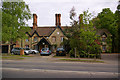
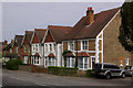
Pimlico Cottages
A range of cottages that once formed part of the Nutfield Priory estate.
Image: © Ian Capper
Taken: 9 May 2009
0.10 miles
2
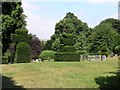
Nutfield Cemetery
Situated north of the A25, west of the village of Nutfield.
Image: © Hywel Williams
Taken: 21 Jul 2005
0.15 miles
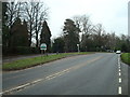
6
High Street
Row of houses at the west end of Nutfield.
Image: © Ian Capper
Taken: 9 May 2009
0.23 miles
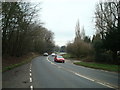
7
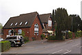
Former Doods Brow School
Former village school, which subsequently became a prep school before closing around 2000. Now converted to housing. The building is locally listed.
Image: © Ian Capper
Taken: 9 May 2009
0.24 miles