IMAGES TAKEN NEAR TO
Clay Lane, REDHILL, RH1 4EG
Introduction
This page details the photographs taken nearby to Clay Lane, RH1 4EG by members of the Geograph project.
The Geograph project started in 2005 with the aim of publishing, organising and preserving representative images for every square kilometre of Great Britain, Ireland and the Isle of Man.

There are currently over 7.5m images from over14,400 individuals and you can help contribute to the project by visiting https://www.geograph.org.uk
Image Map
Images are licensed for reuse under creativecommons.org/licenses/by-sa/2.0
Notes
- Clicking on the map will re-center to the selected point.
- The higher the marker number, the further away the image location is from the centre of the postcode.
Image Listing (33 Images Found)
Images are licensed for reuse under creativecommons.org/licenses/by-sa/2.0
Image
Details
Distance
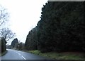
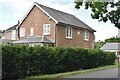
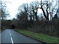
2
Clay Lane, South Nutfield
Towards the A25.
Image: © Robin Webster
Taken: 8 Dec 2022
0.03 miles
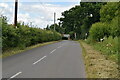
3
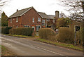
Bundles
This house in Clay Lane has a date plaque of 1859.
Image: © Ian Capper
Taken: 6 Mar 2010
0.04 miles
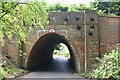
5
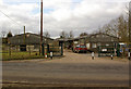
Egg Arch Farm
In Clay Lane. The name presumably derives from the shape of the nearby railway bridge (see Image).
Image: © Ian Capper
Taken: 6 Mar 2010
0.08 miles
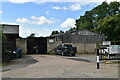
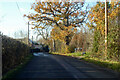
8
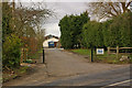
Maple Farm
Maple Farm sits astride a long straight track from Canada Avenue by East Surrey Hospital, known as Canadian Road (see Image for background). It is unfortunate that the route is now blocked by the farm buildings, severing what would be a very useful cycle track.
Image: © Ian Capper
Taken: 6 Mar 2010
0.11 miles