IMAGES TAKEN NEAR TO
Nutfield Road, REDHILL, RH1 4ED
Introduction
This page details the photographs taken nearby to Nutfield Road, RH1 4ED by members of the Geograph project.
The Geograph project started in 2005 with the aim of publishing, organising and preserving representative images for every square kilometre of Great Britain, Ireland and the Isle of Man.

There are currently over 7.5m images from over14,400 individuals and you can help contribute to the project by visiting https://www.geograph.org.uk
Image Map
Images are licensed for reuse under creativecommons.org/licenses/by-sa/2.0
Notes
- Clicking on the map will re-center to the selected point.
- The higher the marker number, the further away the image location is from the centre of the postcode.
Image Listing (14 Images Found)
Images are licensed for reuse under creativecommons.org/licenses/by-sa/2.0
Image
Details
Distance
1

Hunters Lodge
A large Victorian house, now divided into flats. It is shown unnamed on the 1870-72 map, and named Claremont on the 1896-7 map, a name still appearing on the 1966-68 map.
Image: © Ian Capper
Taken: 25 Apr 2011
0.05 miles
2
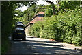
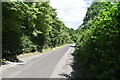
A25 Nutfield Road
Towards Nutfield, passing Nutfield Lodge, 'Conference and banqueting suite' on the right.
Image: © Robin Webster
Taken: 23 Mar 2019
0.14 miles
4
A25 Nutfield Road
Climbing away from Redhill to the top of the Greensand ridge.
Image: © Robin Webster
Taken: 23 Mar 2019
0.17 miles
6
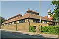
Patteson Court
Patteson Court was a large gothic-style house (see http://www.oldreigate.com/?goto=nutfieldroad ), built for a Mr Norman Wilkinson with building starting in 1847. Its final role was use by Laporte Industries as the headquarters of its Fullers Earth business, and it was demolished in the late 1990s to enable an extension of the Fullers Earth site here, now being used for landfill. The name lives on in these offices, converted from the former stable block/outhouses.
Image: © Ian Capper
Taken: 25 Apr 2011
0.20 miles
7
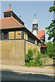
Patteson Court
Patteson Court was a large gothic-style house (see http://www.oldreigate.com/?goto=nutfieldroad ), built for a Mr Norman Wilkinson with building starting in 1847. Its final role was use by Laporte Industries as the headquarters of its Fullers Earth business, and it was demolished in the 1990s to enable an extension of the Fullers Earth site here, now being used for landfill. The name lives on in these offices, converted from the former stable block/outhouses.
Image: © Ian Capper
Taken: 25 Apr 2011
0.20 miles
8
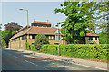
Patteson Court
Patteson Court was a large gothic-style house (see http://www.oldreigate.com/?goto=nutfieldroad ), built for a Mr Norman Wilkinson with building starting in 1847. Its final role was use by Laporte Industries as the headquarters of its Fullers Earth business, and it was demolished in the late 1990s to enable an extension of the Fullers Earth site here, now being used for landfill. The name lives on in these offices, converted from the former stable block/outhouses.
Image: © Ian Capper
Taken: 25 Apr 2011
0.20 miles
9

Copyhold Works
A telephoto view of the former Copyhold Works. Fuller's Earth Union Ltd was incorporated in 1890 amalgamating three quarries of Fuller's Earth found in strata of the Lower Greensand Nutfield Ridge and nearby, as well as some near Bath in Somerset. Its headquarters were at Patteson Court, situated between Nutfield and Redhill (now demolished, but its stable block/outhouses remain - see Image).
In 1954, it was bought by the chemical giant Laporte Industries, who developed the Copyhold processing works seen in the background here, which was situated next to one of the quarries. For the next four decades it was a major producer, including significant exports. However, production ceased in 1996. The site was taken over for waste processing, with the former quarries being used as a major landfill facility, a role they continue to have (the facilities in the foreground are connected with this - methane extraction?). For a few years the Works themselves were used as a waste transfer station, but this has since ceased and they now lie derelict.
The telephoto view has accentuated what would appear to be a heat haze, perhaps caused by the sun on the sheeting used to line the landfill site.
Image: © Ian Capper
Taken: 22 Apr 2012
0.20 miles