IMAGES TAKEN NEAR TO
Muggeridge Road, BILLINGSHURST, RH14 9YY
Introduction
This page details the photographs taken nearby to Muggeridge Road, RH14 9YY by members of the Geograph project.
The Geograph project started in 2005 with the aim of publishing, organising and preserving representative images for every square kilometre of Great Britain, Ireland and the Isle of Man.

There are currently over 7.5m images from over14,400 individuals and you can help contribute to the project by visiting https://www.geograph.org.uk
Image Map
Images are licensed for reuse under creativecommons.org/licenses/by-sa/2.0
Notes
- Clicking on the map will re-center to the selected point.
- The higher the marker number, the further away the image location is from the centre of the postcode.
Image Listing (6 Images Found)
Images are licensed for reuse under creativecommons.org/licenses/by-sa/2.0
Image
Details
Distance
2
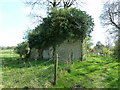
Unknown building north of Billingshurst
Information from Billingshurst History group states that is one of two windmills in the area. The mill lasted until 1906 when it was severely damage in a gale. The last hundred years of neglect has seen further decline.
Image: © Dave Spicer
Taken: 9 Apr 2011
0.18 miles
3
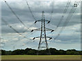
Communication mast in middle of the square
Image: © Dave Spicer
Taken: 9 Apr 2011
0.18 miles
4
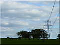
Corner pylon near Billingshurst
This line takes a curving course to avoid Billingshurst, but this is an additional perturbation, possibly to avoid some rural dwellings. Are power line routes laid out on a probability/cost basis, setting possible compensation against additional prime cost?
Image: © Robin Webster
Taken: 29 Aug 2011
0.19 miles
5
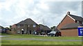
New housing estate, Hammonds, Billingshurst
Image: © David Smith
Taken: 8 Jul 2019
0.23 miles
6
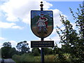
Billingshurst Village Sign
A272 East Street
Image: © Geographer
Taken: 21 Jul 2008
0.24 miles