IMAGES TAKEN NEAR TO
Plaistow, BILLINGSHURST, RH14 0QF
Introduction
This page details the photographs taken nearby to RH14 0QF by members of the Geograph project.
The Geograph project started in 2005 with the aim of publishing, organising and preserving representative images for every square kilometre of Great Britain, Ireland and the Isle of Man.

There are currently over 7.5m images from over14,400 individuals and you can help contribute to the project by visiting https://www.geograph.org.uk
Image Map
Images are licensed for reuse under creativecommons.org/licenses/by-sa/2.0
Notes
- Clicking on the map will re-center to the selected point.
- The higher the marker number, the further away the image location is from the centre of the postcode.
Image Listing (9 Images Found)
Images are licensed for reuse under creativecommons.org/licenses/by-sa/2.0
Image
Details
Distance
1
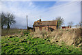
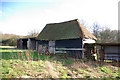
Old Pigsty, Sparrwood Farm
Few of the buildings on this farm appear regularly used, particularly this sty. The chimney and TV antenna beyond belong to the unoccupied farmhouse.
Image: © Robin Webster
Taken: 10 Feb 2007
0.02 miles
2
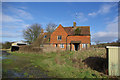
Sparrwood Farm
The farmhouse is now unoccupied - front door wide open - and in danger of dereliction.
Image: © Robin Webster
Taken: 10 Feb 2007
0.02 miles
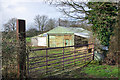
3
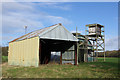
Structures, Sparrwood Farm
Best guess is the elevated structure is for shooting deer, although it seems very small, but why the netted entrance to the far shed? Explanations invited.
Image: © Robin Webster
Taken: 10 Feb 2007
0.02 miles
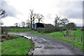
4
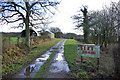
Track towards Sparrwood Farm
At the time this was a public footpath, since diverted. There were no children or animals at the farm, the older buildings near derelict, the farmhouse empty and open.
Image: © Robin Webster
Taken: 10 Feb 2007
0.04 miles
5
Barn, Sparrwood Farm
The woodland beyond is Sparrwood Hanger.
Image: © Robin Webster
Taken: 10 Feb 2007
0.05 miles
6
Barn near Sparrwood Farm
At the time a public footpath passed by here, it has since been diverted.
Image: © Robin Webster
Taken: 10 Feb 2007
0.06 miles
7
Nissen hut barn near Sparrwood Farm
At the junction of a bridleway and footpath, the path goes left following the farm track to Sparrwood Farm, then unoccupied. The path has since been diverted away from the farm, whose site has been converted into a country residence. The barn has since been demolished.
Image: © Robin Webster
Taken: 10 Feb 2007
0.22 miles
8
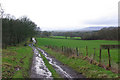
Track to Sparrwood Farm
This is also a public bridleway over this section. The farm track turns left at a faintly discernible barn, and the bridleway continues straight on unsurfaced. The high ground capped by cloud in the distance is about 5 miles away and is Black Down, the highest point in Sussex. It is not chalk but greensand.
Image: © Robin Webster
Taken: 10 Feb 2007
0.23 miles
9
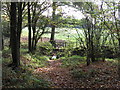
Footbridge and stile at the southern edge of Red Copse
Image: © Dave Spicer
Taken: 31 Oct 2009
0.25 miles