IMAGES TAKEN NEAR TO
Bletchingley Road, REDHILL, RH1 3QN
Introduction
This page details the photographs taken nearby to Bletchingley Road, RH1 3QN by members of the Geograph project.
The Geograph project started in 2005 with the aim of publishing, organising and preserving representative images for every square kilometre of Great Britain, Ireland and the Isle of Man.

There are currently over 7.5m images from over14,400 individuals and you can help contribute to the project by visiting https://www.geograph.org.uk
Image Map
Images are licensed for reuse under creativecommons.org/licenses/by-sa/2.0
Notes
- Clicking on the map will re-center to the selected point.
- The higher the marker number, the further away the image location is from the centre of the postcode.
Image Listing (44 Images Found)
Images are licensed for reuse under creativecommons.org/licenses/by-sa/2.0
Image
Details
Distance
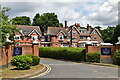
4

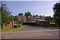
Coppice Lea
Coppice Lea is a care home on the edge of Merstham. It was originally built in 1880 as a family home but now provides residential and nursing care for up to 51 residents. It has five acres of grounds which while no doubt pleasant enough must be somewhat marred by the constant din from the adjacent motorways. See Image
for a similar view taken nine years previously - not much appears to have changed.
Image: © Stephen McKay
Taken: 22 Nov 2017
0.09 miles
5

Spynes Mere
Path alongside the north of Spynes Mere, a former sand quarry now managed as a nature reserve by Surrey Wildlife Trust. In the background is an artificial sand cliff built to provide a nesting site for Sand Martins (Riparia riparia) - see Image for more detail.
Image: © Ian Capper
Taken: 30 Apr 2021
0.09 miles
6
Coppice Lea, Merstham
Originally built in the 1880s, this is now a care home.
Image: © Ian Capper
Taken: 8 Jun 2008
0.09 miles
7
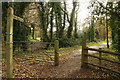
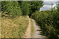
Bridleway from Bletchingley Road
The bridleway is part of a network of paths in the area to the south-east of Merstham. It will eventually take the walker or rider to Nutfield.
Image: © Stephen McKay
Taken: 22 Nov 2017
0.10 miles
8
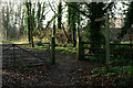
Bridleway in Merstham, Surrey
The bridleway runs south, then east, before linking with another bridleway which continues towards Nutfield Marsh.
Image: © Peter Trimming
Taken: 10 Dec 2013
0.10 miles
10
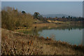
Spynes Mere Nature Reserve, Merstham
When I was last through here, in about 2004, I was cycling too fast to admire the extensive nature reserve, of which this is a part. The North Downs can be seen, in the distance.
Image: © Peter Trimming
Taken: 10 Dec 2013
0.12 miles