IMAGES TAKEN NEAR TO
Southcote Road, REDHILL, RH1 3LJ
Introduction
This page details the photographs taken nearby to Southcote Road, RH1 3LJ by members of the Geograph project.
The Geograph project started in 2005 with the aim of publishing, organising and preserving representative images for every square kilometre of Great Britain, Ireland and the Isle of Man.

There are currently over 7.5m images from over14,400 individuals and you can help contribute to the project by visiting https://www.geograph.org.uk
Image Map
Images are licensed for reuse under creativecommons.org/licenses/by-sa/2.0
Notes
- Clicking on the map will re-center to the selected point.
- The higher the marker number, the further away the image location is from the centre of the postcode.
Image Listing (62 Images Found)
Images are licensed for reuse under creativecommons.org/licenses/by-sa/2.0
Image
Details
Distance
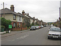
1
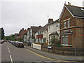
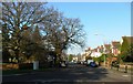
Southcote Road
Part of the late Victorian development of South Merstham. It is named after the Southcote family who owned the Manor of Albury from the 16th to 18th centuries.
Image: © Ian Capper
Taken: 7 May 2009
0.02 miles
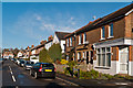
2
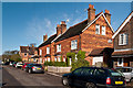
Southcote Road
Late Victorian cottages in this road linking Albury Road and Nutfield Road. Although they are identical in appearance, the 1896 1:2500 map only shows the left hand of the pair, with the rest of the road undeveloped.
Image: © Ian Capper
Taken: 21 Apr 2012
0.02 miles
3
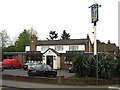
The Limes
At the junction of Southcote Road and Albury Road
Image: © Ian Capper
Taken: 7 May 2009
0.03 miles
4
Endsleigh Road at the junction of Albury Road
Image: © David Howard
Taken: 24 Jan 2016
0.05 miles
5
Albury Road
Part of the late Victorian development of South Merstham. The name refers to the Manor of Albury, the site of which is behind these houses. The green sign on the left is at the access point to a local recreation ground.
Image: © Ian Capper
Taken: 7 May 2009
0.05 miles
6
Endsleigh Road
Development of this road started in the 1890s. The building on the right would appear to have once been a corner shop.
Image: © Ian Capper
Taken: 21 Apr 2012
0.06 miles
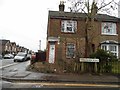
7
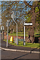
Signpost
Signpost at the junction of Nutfield Road with Battlebridge Lane.
Image: © Ian Capper
Taken: 21 Apr 2012
0.07 miles
8
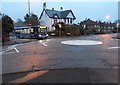
Roundabout on Battlebridge Lane, Merstham
Image: © David Howard
Taken: 24 Jan 2016
0.07 miles
10
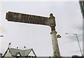
Old Direction Sign - Signpost by Nutfield Road, Reigate Parish
Pawn finial - 1 arm; Surrey scallop arm by the UC road, in parish of Reigate (Reigate and Banstead District), Nutfield Road junction with Battlebridge Lane, Merstham, on grass.
Surveyed
Milestone Society National ID: SY_TQ2952
Image: © Milestone Society
Taken: Unknown
0.07 miles