IMAGES TAKEN NEAR TO
Worthing Road, HORSHAM, RH13 9HA
Introduction
This page details the photographs taken nearby to Worthing Road, RH13 9HA by members of the Geograph project.
The Geograph project started in 2005 with the aim of publishing, organising and preserving representative images for every square kilometre of Great Britain, Ireland and the Isle of Man.

There are currently over 7.5m images from over14,400 individuals and you can help contribute to the project by visiting https://www.geograph.org.uk
Image Map (Loading...)


Getting Data...Please wait
Leaflet Map data © OpenStreetMap
Images are licensed for reuse under creativecommons.org/licenses/by-sa/2.0
Notes
- Clicking on the map will re-center to the selected point.
- The higher the marker number, the further away the image location is from the centre of the postcode.
Image Listing (16 Images Found)
Images are licensed for reuse under creativecommons.org/licenses/by-sa/2.0
Image
Details
Distance
1
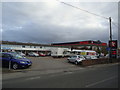
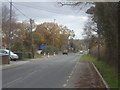
Godfreys of Horsham, Worthing Road, Southwater
Image: © Stacey Harris
Taken: 26 Nov 2011
0.03 miles
5
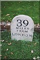
Modern Milestone by Worthing Road, Southwater parish
Carved stone post by the UC road (was A24), in parish of SOUTHWATER (HORSHAM District), Worthing Road, in front of "The Old School", against low wall, on West side of road. Lionel Joseph replica, erected by the Horsham & Steyning turnpike trust in the 19th century.
Inscription reads:-
39
MILES
FROM
LONDON
Milestone Society National ID: SX_LA39R.
Image: © C Woodward
Taken: 14 Oct 2010
0.05 miles
9
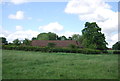
Mostly buried bridge by Downs Link trail
The Downs Link trail normally uses the trackbed of the old railway, but here a cutting has been filled in. The trail follows a roughly parallel course to one side of where the cutting was. Showing here is the north end of a bridge parapet which extends to the left, mainly obscured by vegetation.
Image: © Robin Webster
Taken: 22 Oct 2010
0.23 miles