IMAGES TAKEN NEAR TO
Ivy Close, HORSHAM, RH13 9EF
Introduction
This page details the photographs taken nearby to Ivy Close, RH13 9EF by members of the Geograph project.
The Geograph project started in 2005 with the aim of publishing, organising and preserving representative images for every square kilometre of Great Britain, Ireland and the Isle of Man.

There are currently over 7.5m images from over14,400 individuals and you can help contribute to the project by visiting https://www.geograph.org.uk
Image Map
Images are licensed for reuse under creativecommons.org/licenses/by-sa/2.0
Notes
- Clicking on the map will re-center to the selected point.
- The higher the marker number, the further away the image location is from the centre of the postcode.
Image Listing (51 Images Found)
Images are licensed for reuse under creativecommons.org/licenses/by-sa/2.0
Image
Details
Distance
1
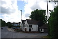
The Cock Inn, Southwater
Grade II listed. http://www.britishlistedbuildings.co.uk/en-299283-the-cock-inn-southwater
Image: © N Chadwick
Taken: 8 May 2011
0.04 miles
5
The old Southwater Station
Now on the Downs Link path.
Image: © N Chadwick
Taken: 8 May 2011
0.09 miles
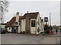
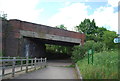
7
Southwater Station
Closed many years ago, now on the Downs Link.
Image: © N Chadwick
Taken: 8 May 2011
0.10 miles
8
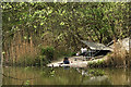
Fishing shelter, Southwater Country Park
Fishing is not permitted in the, larger, Cripplegate Lake.
Image: © Andy Potter
Taken: 29 Apr 2006
0.10 miles
9
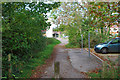
Downs Link, Southwater
The trail from South to North Downs largely follows the old railways from Shoreham to Christ's Hospital and onwards towards Guildford. This is the case here.
Image: © Robin Webster
Taken: 22 Oct 2010
0.10 miles
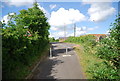
10
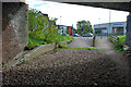
Signs of the old station, Southwater
The platform end is still there, partially buried, under the bridge. The road over the bridge is now diverted to the route seen ahead, and the course of the railway is used by the Downs Link trail.
Image: © Robin Webster
Taken: 22 Oct 2010
0.10 miles