IMAGES TAKEN NEAR TO
Acorn Avenue, HORSHAM, RH13 8RS
Introduction
This page details the photographs taken nearby to Acorn Avenue, RH13 8RS by members of the Geograph project.
The Geograph project started in 2005 with the aim of publishing, organising and preserving representative images for every square kilometre of Great Britain, Ireland and the Isle of Man.

There are currently over 7.5m images from over14,400 individuals and you can help contribute to the project by visiting https://www.geograph.org.uk
Image Map
Images are licensed for reuse under creativecommons.org/licenses/by-sa/2.0
Notes
- Clicking on the map will re-center to the selected point.
- The higher the marker number, the further away the image location is from the centre of the postcode.
Image Listing (53 Images Found)
Images are licensed for reuse under creativecommons.org/licenses/by-sa/2.0
Image
Details
Distance
1
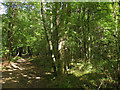
Eastlands Wood
Following the footpath that links East lands Lane to Bolney Road, the A272.
Image: © Simon Carey
Taken: 30 Aug 2010
0.08 miles
2
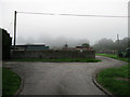
Cowfold Sewage Works
Dating from the 1930s and built on a site used as a sewage farm from the late 19th century.
Image: © Simon Carey
Taken: 4 Sep 2010
0.11 miles
3
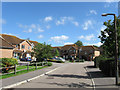
Holm Oaks
A cul-de-sac off Oakfield Road built in the mid 1980s.
Image: © Simon Carey
Taken: 30 Aug 2010
0.11 miles
4
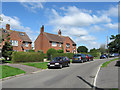
Oakfield Road
Part of a postwar housing estate built south of Bolney Road, the A272. This looks towards the junction with it, the only access to the estate and the additional one built in the mid 1980s.
Image: © Simon Carey
Taken: 30 Aug 2010
0.11 miles
5
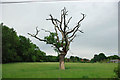
Not quite dead oak
It's seen better days, and this oak is just managing to produce some greenery for 2010.
Image: © Robin Webster
Taken: 7 Jun 2010
0.12 miles
6
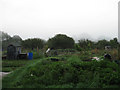
Allotments, Eastlands Lane
Located next to the sewage works in a field called West Mead according to the 1840 tithe map.
Image: © Simon Carey
Taken: 4 Sep 2010
0.12 miles
7
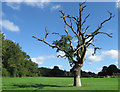
Stone Field
The name of the field according to the 1840 tithe map. The old oak is a remnant of a former hedgerow. Eastlands Wood is to the left .
Image: © Simon Carey
Taken: 30 Aug 2010
0.12 miles
8
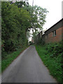
Eastlands Lane
A private road linking Eastlands Farm to Henfield Road though the route is a public footpath. The buildings on the right belong to Fowlers building company who have been operating in the village since 1890.
Image: © Simon Carey
Taken: 4 Sep 2010
0.13 miles
9
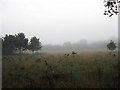
Little Upper Field
The name of the field according to the 1840 tithe map shrouded in early morning mist.
Image: © Simon Carey
Taken: 4 Sep 2010
0.13 miles
10
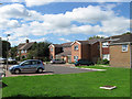
Mercers Mead
A small cul-de-sac off Oakfield Road originally built in the immediate postwar period and infilled during the 1980s. The close is named after a nearby field which is now part of the recreation ground.
Image: © Simon Carey
Taken: 30 Aug 2010
0.14 miles