IMAGES TAKEN NEAR TO
The Rosary, HORSHAM, RH13 8QX
Introduction
This page details the photographs taken nearby to The Rosary, RH13 8QX by members of the Geograph project.
The Geograph project started in 2005 with the aim of publishing, organising and preserving representative images for every square kilometre of Great Britain, Ireland and the Isle of Man.

There are currently over 7.5m images from over14,400 individuals and you can help contribute to the project by visiting https://www.geograph.org.uk
Image Map
Images are licensed for reuse under creativecommons.org/licenses/by-sa/2.0
Notes
- Clicking on the map will re-center to the selected point.
- The higher the marker number, the further away the image location is from the centre of the postcode.
Image Listing (139 Images Found)
Images are licensed for reuse under creativecommons.org/licenses/by-sa/2.0
Image
Details
Distance
1
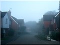
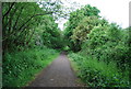
The Rosary, Partridge Green
A small residential estate built around 2004 in the former grounds of Image and other houses to the south. At the western end the road turns south into Image Viewed on a foggy morning.
Image: © Simon Carey
Taken: 23 Sep 2016
0.01 miles
2
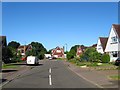
Bedford Square, Partridge Green
A small cul de sac off Image which was built around 2004 in the grounds of Hillview, Lynmede and Mayfield who themselves occupied a former field called Barley Plat according to West Grinstead's 1841 tithe map.
Image: © Simon Carey
Taken: 23 Sep 2016
0.03 miles
3
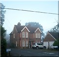
The Rosary, Church Road, Partridge Green
The house was built in the first decade of the 20th century and for a time was known as Wildacre. Around 2003 a small estate containing Image and Image was built in the former extensive grounds to the rear which originally stretched west to the former Shoreham-Christ's Hospital railway.
Image: © Simon Carey
Taken: 23 Sep 2016
0.04 miles
6
Downlands, Partridge Green
A cul de sac off Church Road that was built in the mid 1970s on a field called Three Acres according to West Grinstead's 1841 tithe map.
Image: © Simon Carey
Taken: 9 Aug 2016
0.07 miles
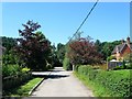
7
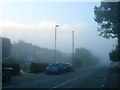
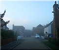
Church Road, Partridge Green
Viewed on a very foggy morning. The houses just in view from left to right are Ventura, Kingsdown, West Winds and South Winds mostly built between the wars.
Image: © Simon Carey
Taken: 23 Sep 2016
0.07 miles
8
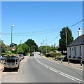
Church Road, Partridge Green
The B2135 heading north from the junction with High Street. On the right is part of Image
Image: © Simon Carey
Taken: 19 Jul 2016
0.07 miles
9
Church Lane, Partridge Green
The access road for Image from Church Road, the B2135. The house on the right is St Michael's Lodge which appears to have been built at the same time as the church.
Image: © Simon Carey
Taken: 19 Jul 2016
0.08 miles
10
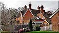
Rear view of large house near the church
This house is on the B2135.
Image: © Ian Hawfinch
Taken: 18 Feb 2020
0.08 miles