IMAGES TAKEN NEAR TO
Worthing Road, HORSHAM, RH13 8NH
Introduction
This page details the photographs taken nearby to Worthing Road, RH13 8NH by members of the Geograph project.
The Geograph project started in 2005 with the aim of publishing, organising and preserving representative images for every square kilometre of Great Britain, Ireland and the Isle of Man.

There are currently over 7.5m images from over14,400 individuals and you can help contribute to the project by visiting https://www.geograph.org.uk
Image Map
Images are licensed for reuse under creativecommons.org/licenses/by-sa/2.0
Notes
- Clicking on the map will re-center to the selected point.
- The higher the marker number, the further away the image location is from the centre of the postcode.
Image Listing (56 Images Found)
Images are licensed for reuse under creativecommons.org/licenses/by-sa/2.0
Image
Details
Distance
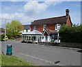
1

The Crown, Worthing Road, Dial Post
Dating from the 19th century and the only real amenity left in the small hamlet other than the village hall. The former stable block to the rear on the left is used for bed and breakfast.
Image: © Simon Carey
Taken: 23 Jul 2016
0.00 miles
2
The Crown Inn at Dial Post
By the old Worthing road.
The present A24 - one of Sussex's less appealing features - bypasses the village a couple of hundred yards to the east.
Simon Carey's contribution: Image shows the Crown Inn as it was 13 years earlier - with a pub sign in more traditional style.
Image: © Stefan Czapski
Taken: 8 Jul 2019
0.01 miles
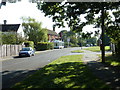
3

Alma Cottage, Worthing Road, Dial Post
Small cottage to the immediate south of Image that dates back to the 18th century.
Image: © Simon Carey
Taken: 23 Jul 2016
0.01 miles
6
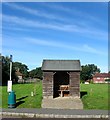
Bus Shelter, Worthing Road, Dial Post
Located opposite Image and rarely used for its purpose as Dial Post is only served by one bus a week every Wednesday. Beyond is The Green.
Image: © Simon Carey
Taken: 23 Sep 2016
0.02 miles
7

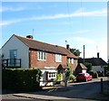
Pengates, Worthing Road, Dial Post
Part of the house is believed to date back to the 17th century which was extended in the late 19th century becoming the local village stores and later Post Office. Now a private residence.
Image: © Simon Carey
Taken: 23 Jul 2016
0.02 miles
8
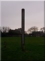
Dial Post: village sign
The village sign for Dial Post.
Image: © mcc
Taken: 5 Jan 2018
0.03 miles
9
The Old Granary/The Old Cottage, Worthing Road, Dial Post
The Old Granary is to the left and appears to have been a former barn called Rose cottage on the 1974 OS map. The Old Cottage is the weatherboarded property at the end of the drive and has been converted into two dwellings.
Image: © Simon Carey
Taken: 23 Sep 2016
0.03 miles
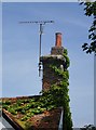
10

Hazel Cottage, Worthing Road, Dial Post
A listed building erected sometime in the 17th century.
Image: © Simon Carey
Taken: 23 Jul 2016
0.03 miles