IMAGES TAKEN NEAR TO
Cowfold Road, HORSHAM, RH13 8LP
Introduction
This page details the photographs taken nearby to Cowfold Road, RH13 8LP by members of the Geograph project.
The Geograph project started in 2005 with the aim of publishing, organising and preserving representative images for every square kilometre of Great Britain, Ireland and the Isle of Man.

There are currently over 7.5m images from over14,400 individuals and you can help contribute to the project by visiting https://www.geograph.org.uk
Image Map (Loading...)


Getting Data...Please wait
Leaflet Map data © OpenStreetMap
Images are licensed for reuse under creativecommons.org/licenses/by-sa/2.0
Notes
- Clicking on the map will re-center to the selected point.
- The higher the marker number, the further away the image location is from the centre of the postcode.
Image Listing (31 Images Found)
Images are licensed for reuse under creativecommons.org/licenses/by-sa/2.0
Image
Details
Distance
1
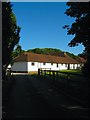
Stables, Model Farm
Built between the wars by the West Grinstead Park estate but sold in 1973 when it was broken up. The block is now used by Sussex Saddlery who cater for the equestrian needs of private owners and polo players.
Image: © Simon Carey
Taken: 19 Jul 2016
0.02 miles
2
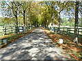
Driveway to Model Farm
Although I couldn't see a name, the name on the WSCC map is Model Farm.
Image: © Dave Spicer
Taken: 27 Sep 2011
0.05 miles
3
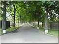
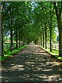
Tree-lined drive to Model Farm Cottages
This is also a public footpath
Image: © David Smith
Taken: 8 Jul 2019
0.05 miles
4
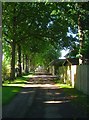
Drive to Model Farm Cottages
Looking southwards along the drive which connects the cottages and adjacent stables to the A272 where another continues southwards to Park Farm, see Image The drive was laid out sometime during the interwar years.
Image: © Simon Carey
Taken: 19 Jul 2016
0.06 miles
5
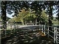
Footpath 1793 crosses the A272
View from the drive of the Old Sussex Stud looking towards Model Buildings Cottages.
Image: © Andy Potter
Taken: 20 Sep 2006
0.07 miles
7
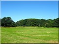
Bottings Croft
The name of the field according to West Grinstead's 1841 tithe map that is located to the north of Model Farm Cottages. Buck Wood is the wood at the far end of the field.
Image: © Simon Carey
Taken: 19 Jul 2016
0.09 miles
8
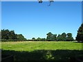
Old Brick Yard Field
The name of the field according to West Grinstead's 1841 tithe map. This is the south western part adjacent to the A272 with the area immediately to the north occupied by Image Another section lies to the east of Image
Image: © Simon Carey
Taken: 19 Jul 2016
0.09 miles
9
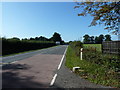
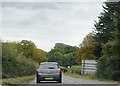
View west on the A272 towards Buckbarn Crossroads
Image: © Dave Spicer
Taken: 27 Sep 2011
0.10 miles
10
Drive to Park Farm
Looking northwards from the edge of park Farm towards the A272. Beyond is another treelined drive to Model Farm Cottages, see Image Either side of this drive is Image to the left and Image to the right.
Image: © Simon Carey
Taken: 19 Jul 2016
0.10 miles