IMAGES TAKEN NEAR TO
Mill Lane, HORSHAM, RH13 8JU
Introduction
This page details the photographs taken nearby to Mill Lane, RH13 8JU by members of the Geograph project.
The Geograph project started in 2005 with the aim of publishing, organising and preserving representative images for every square kilometre of Great Britain, Ireland and the Isle of Man.

There are currently over 7.5m images from over14,400 individuals and you can help contribute to the project by visiting https://www.geograph.org.uk
Image Map
Images are licensed for reuse under creativecommons.org/licenses/by-sa/2.0
Notes
- Clicking on the map will re-center to the selected point.
- The higher the marker number, the further away the image location is from the centre of the postcode.
Image Listing (87 Images Found)
Images are licensed for reuse under creativecommons.org/licenses/by-sa/2.0
Image
Details
Distance
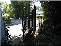
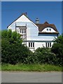
2
House on Mill Lane seen from footpath junction
Image: © Shazz
Taken: 10 Sep 2015
0.03 miles
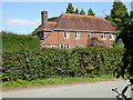
3
Little Mill, Mill Lane, Jolesfield Common
Large house built in the 1950s on Mill Lane.
Image: © Simon Carey
Taken: 19 Jul 2016
0.03 miles
4
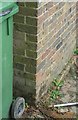
Ordnance Survey Bench mark
CUT MARK: MOUNT PLEASANT N FACE NW ANG (ODN 24.9083m, AGL 0.5m).
Image: © The Saunterer
Taken: 13 Aug 2012
0.03 miles
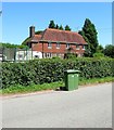
5
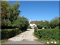
Old Mill House, Mill Lane, Jolesfield Common
The house dates from the late 18th century though much of the front was rebuilt after a fire in the 1930s. It served as the millers house for Joelsfield Windmill which was built in 1788 further up the slope to the rear of the property. It ceased operating in 1909 and was derelict by the 1920s. It was dismantled in 1959 with the machinery taken to Gatwick Manor in where the owner hoped to reassemble it as part of a generator, though the pieces were eventually used as an attraction in the hotel's garden. Only the brick base survives today. To the rear of the property is Image
Image: © Simon Carey
Taken: 19 Jul 2016
0.06 miles
6
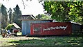
You Can't Beat The Feeling! (apparently)
Before I googled this I had no idea it was an advertisement for Coca Cola. I'm not sure how this trailer ended up behind the garden of this house, but there's also quite a lot of random junk by the path further along - between the houses.
Image: © Ian Hawfinch
Taken: 25 Apr 2020
0.06 miles
7
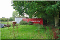
Path through a linear junk yard
The public footpath squeezes between the back of several large sheds and the hedge. However, a lot of the available space is occupied by small collapsing wooden sheds full of junk. Where there is no space for such sheds, there is a linear collection of mainly automotive junk, with an admixture of horse-drawn vehicle junk. Admittedly there is room to get past, just.
Image: © Robin Webster
Taken: 30 Sep 2010
0.06 miles
8
Site of Jolesfield Brickworks
A brickworks was in existence on Jolesfield Common by the 1780s and steadily grew throughout the 19th century. Clay was dug on the common with the old kilns and other buildings in the foreground and where the bushes are located. The enclosure of the common in 1872 limited the expansion of the works which was still producing bricks, tiles and pottery into the 20th century but had closed within the first decade of that century. The field in the distance was known as New Plat on West Grinstead's 1841 tithe map.
Image: © Simon Carey
Taken: 11 Sep 2016
0.07 miles
9
Quince Cottage, Mill Lane, Jolesfield Common
An 18th century cottage originally built facing out onto Jolesfield Common whose enclosure in 1872 has eventually provided the dwelling with its large front garden.
Image: © Simon Carey
Taken: 11 Sep 2016
0.08 miles
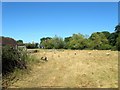
10
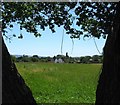
Mill Plat
The name of the field according to West Grinstead's 1841 tithe map that is located to the south of Image At the far end is the rear view of Image Jolesfield Windmill stood in the north east corner of the field out of shot to the left. It was built in 1788, operated until around 1909 and was demolished in 1959 with only the brick base surviving.
Image: © Simon Carey
Taken: 19 Jul 2016
0.09 miles