IMAGES TAKEN NEAR TO
Kent Street, HORSHAM, RH13 8BA
Introduction
This page details the photographs taken nearby to Kent Street, RH13 8BA by members of the Geograph project.
The Geograph project started in 2005 with the aim of publishing, organising and preserving representative images for every square kilometre of Great Britain, Ireland and the Isle of Man.

There are currently over 7.5m images from over14,400 individuals and you can help contribute to the project by visiting https://www.geograph.org.uk
Image Map
Images are licensed for reuse under creativecommons.org/licenses/by-sa/2.0
Notes
- Clicking on the map will re-center to the selected point.
- The higher the marker number, the further away the image location is from the centre of the postcode.
Image Listing (7 Images Found)
Images are licensed for reuse under creativecommons.org/licenses/by-sa/2.0
Image
Details
Distance
1
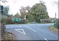
Junction of A272 and Kentstreet Lane, West Sussex
View taken from the N. Kentstreet Lane leads straight ahead (S) from the junction. The road leading N (behind the photographer) goes to Warninglid.
Image: © Pete Chapman
Taken: 30 Nov 2005
0.05 miles
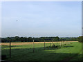
2
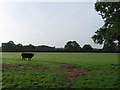
Broad Mead
The name of the field according to the 1840 tithe map. The hedge at the end of the field marks the course of the A272.
Image: © Simon Carey
Taken: 4 Sep 2010
0.13 miles
3
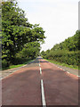
Bolney Road
The stretch of the A272 which runs between Bolney Crossways and Cowfold. The section of the road between Crosspost and Oakendene Manor was built as new in 1825 with the reminder of the route following existing farm lanes. Today it is a very busy east-west route across much of Sussex.
Image: © Simon Carey
Taken: 4 Sep 2010
0.15 miles
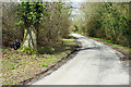
4
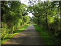
Kent Street Lane
Minor lane linking Bolney Road, the A272, with Winheam Lane via the small settlement of Kent Street.
Image: © Simon Carey
Taken: 4 Sep 2010
0.15 miles
5
Neat fly-tipping, Picts Lane
A black sack discreetly placed behind a tree trunk. On inspection, nothing more sinister than ordinary domestic rubbish.
Image: © Robin Webster
Taken: 5 Apr 2010
0.20 miles
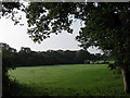
6
The Four Acres/The Five Acres
The name of the fields according to the 1840 tithe map which have been joined together to form a much larger modern field. Viewed from Picts Lane.
Image: © Simon Carey
Taken: 4 Sep 2010
0.23 miles
7
West Moore
The name of the field according to the 1840 tithe map. Any field name with moor or moore in describes barren waste land with this one lying between Kent Street Lane and a small unnamed stream which probably made it too boggy to use effectively in the past.
Image: © Simon Carey
Taken: 4 Sep 2010
0.24 miles