IMAGES TAKEN NEAR TO
Leechpond Hill, HORSHAM, RH13 6NR
Introduction
This page details the photographs taken nearby to Leechpond Hill, RH13 6NR by members of the Geograph project.
The Geograph project started in 2005 with the aim of publishing, organising and preserving representative images for every square kilometre of Great Britain, Ireland and the Isle of Man.

There are currently over 7.5m images from over14,400 individuals and you can help contribute to the project by visiting https://www.geograph.org.uk
Image Map
Images are licensed for reuse under creativecommons.org/licenses/by-sa/2.0
Notes
- Clicking on the map will re-center to the selected point.
- The higher the marker number, the further away the image location is from the centre of the postcode.
Image Listing (45 Images Found)
Images are licensed for reuse under creativecommons.org/licenses/by-sa/2.0
Image
Details
Distance
1
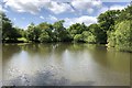
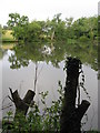
Leech Pond
Leech Pond near Lower Beeding viewed from the B2110 (Leechpond Hill). The water from the pond feeds into the nearby ponds in Leonardslee Gardens.
Image: © Chris Thomas-Atkin
Taken: 24 May 2020
0.05 miles
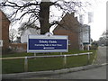
3
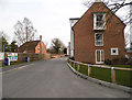
Trinity Fields, Lower Beeding
This is a newly built development of 4-5 bedroom houses, it is not yet on the Ordnance Survey map as of April 2013.
Image: © David Howard
Taken: 7 Apr 2013
0.15 miles
4
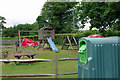
Play area and glass recycling
Behind The Plough, Lower Beeding.
Image: © Robin Webster
Taken: 9 Jun 2010
0.16 miles
6
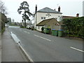
Sandygate Lane
The B2115 close to Trinity Fields and the Plough Inn at Lower Beeding.
Image: © Chris Thomas-Atkin
Taken: 24 May 2020
0.18 miles
7
Entrance to Trinity Fields on Sandygate Lane
This is a newly built development of 4-5 bedroom houses
Image: © David Howard
Taken: 7 Apr 2013
0.18 miles
8
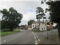
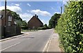
Road junction in Lower Beeding
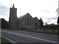
The Plough pub at the junction, the church to my right
Image: © Martin Dawes
Taken: 27 Jul 2020
0.18 miles
9
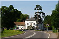
Road Junction at Lower Beeding, Sussex
The B2110 curves round to the left, while the B2115 runs to the right. The front of "The Plough" is just inside this grid square.
Image: © Peter Trimming
Taken: 5 Jun 2010
0.20 miles