IMAGES TAKEN NEAR TO
Vincent Close, HORSHAM, RH13 5LY
Introduction
This page details the photographs taken nearby to Vincent Close, RH13 5LY by members of the Geograph project.
The Geograph project started in 2005 with the aim of publishing, organising and preserving representative images for every square kilometre of Great Britain, Ireland and the Isle of Man.

There are currently over 7.5m images from over14,400 individuals and you can help contribute to the project by visiting https://www.geograph.org.uk
Image Map
Images are licensed for reuse under creativecommons.org/licenses/by-sa/2.0
Notes
- Clicking on the map will re-center to the selected point.
- The higher the marker number, the further away the image location is from the centre of the postcode.
Image Listing (16 Images Found)
Images are licensed for reuse under creativecommons.org/licenses/by-sa/2.0
Image
Details
Distance
1
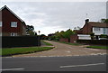
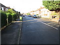
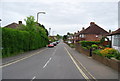
Horsham, Brighton road
Brighton road, Horsham. The A281 heading up a slight hill south-west to Brighton via Cowfold and Henfield.
Image: © Peter Cox
Taken: 4 Apr 2007
0.03 miles
3
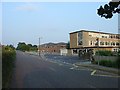
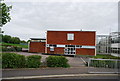
Millais School, Horsham, West Sussex
A local authority girls' comprehensive school (Ages 11-16). General catchment area is Horsham and surrounding villages.
Image: © Pete Chapman
Taken: 13 Jul 2005
0.17 miles
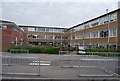
7
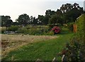
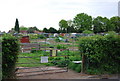
Depot Road Allotments, Horsham, West Sussex
An area of allotments administered by Horsham District Council. Over the road from Millais School.
Image: © Pete Chapman
Taken: 13 Jul 2005
0.20 miles