IMAGES TAKEN NEAR TO
Devonshire Road, HORSHAM, RH13 5EF
Introduction
This page details the photographs taken nearby to Devonshire Road, RH13 5EF by members of the Geograph project.
The Geograph project started in 2005 with the aim of publishing, organising and preserving representative images for every square kilometre of Great Britain, Ireland and the Isle of Man.

There are currently over 7.5m images from over14,400 individuals and you can help contribute to the project by visiting https://www.geograph.org.uk
Image Map (Loading...)


Getting Data...Please wait
Leaflet Map data © OpenStreetMap
Images are licensed for reuse under creativecommons.org/licenses/by-sa/2.0
Notes
- Clicking on the map will re-center to the selected point.
- The higher the marker number, the further away the image location is from the centre of the postcode.
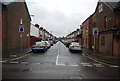
Image Listing (175 Images Found)
Images are licensed for reuse under creativecommons.org/licenses/by-sa/2.0
Image
Details
Distance
2
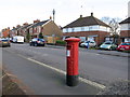
Edwardian Post Box
RH13 97 Clarence Road (Horsham)
Image: © The Saunterer
Taken: 2 Feb 2013
0.05 miles
3
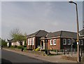
St. Leonard's Community Infant and Nursery School
I think it was originally opened in 1915 as a girls' council.
Image: © Andy Potter
Taken: 17 Apr 2007
0.06 miles
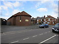
7
St. Leonard's Church
In Cambridge Road by the junction with Clarence Road this, rather austere, church was built in 1939.
Image: © Andy Potter
Taken: 22 May 2007
0.07 miles
9
St. Leonard's Church
Corner of Clarence Road and Cambridge Road
Image: © The Saunterer
Taken: 2 Feb 2013
0.08 miles