IMAGES TAKEN NEAR TO
Barnes Wallis Avenue, HORSHAM, RH13 0TL
Introduction
This page details the photographs taken nearby to Barnes Wallis Avenue, RH13 0TL by members of the Geograph project.
The Geograph project started in 2005 with the aim of publishing, organising and preserving representative images for every square kilometre of Great Britain, Ireland and the Isle of Man.

There are currently over 7.5m images from over14,400 individuals and you can help contribute to the project by visiting https://www.geograph.org.uk
Image Map (Loading...)


Getting Data...Please wait
Leaflet Map data © OpenStreetMap
Images are licensed for reuse under creativecommons.org/licenses/by-sa/2.0
Notes
- Clicking on the map will re-center to the selected point.
- The higher the marker number, the further away the image location is from the centre of the postcode.
Image Listing (111 Images Found)
Images are licensed for reuse under creativecommons.org/licenses/by-sa/2.0
Image
Details
Distance
5
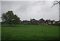
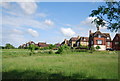
Parts of Christ's Hospital School.
Part of the Bluecoats foundation. Over 450 years old. http://www.christs-hospital.org.uk/
Image: © N Chadwick
Taken: 2 May 2010
0.04 miles
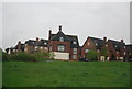
6
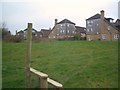
Town Houses
On Bluecoat Pond at Christ's Hospital
Image: © The Saunterer
Taken: 23 Feb 2013
0.06 miles
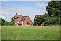
7
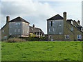
Housing on Bluecoat Pond (road)
An outer ring of more modern housing on the estate associated with Christ's Hospital School.
Image: © Robin Webster
Taken: 3 Apr 2011
0.06 miles
8
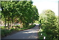
Station Rd
Leading, as its name suggests to the railway station.
Image: © N Chadwick
Taken: 8 May 2011
0.07 miles
9
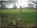
Stile on Public Footpath
FP1628/3 at Christ's Hospital
Image: © The Saunterer
Taken: 23 Feb 2013
0.07 miles
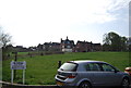
10
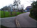
Junction of roads by Christ's Hospital Station
Image: © Shazz
Taken: 3 Mar 2016
0.08 miles